File:SEA-ME-WE-2-Route.svg

Size of this PNG preview of this SVG file: 800 × 548 pixels. Other resolutions: 320 × 219 pixels | 640 × 438 pixels | 1,024 × 702 pixels | 1,280 × 877 pixels | 2,560 × 1,754 pixels | 994 × 681 pixels.
Original file (SVG file, nominally 994 × 681 pixels, file size: 1.13 MB)
Captions
Captions
Add a one-line explanation of what this file represents
Summary edit
| Description |
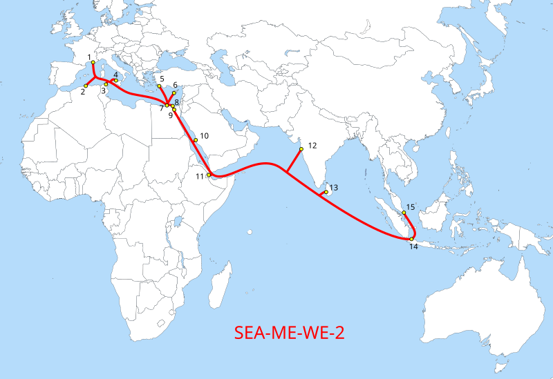
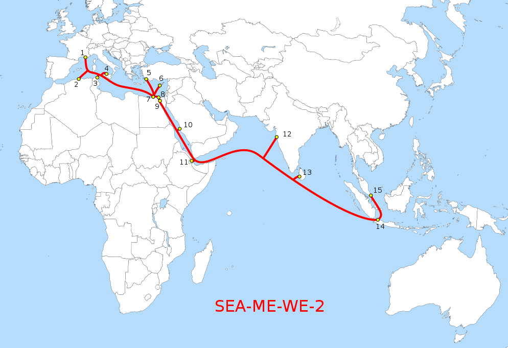
Deutsch: Routen des SEA-ME-WE-2 “South-East Asia - Middle East - Western Europe 2”-Seekabel-Netzes. Beachte: die Karte soll nur die Konnektivitäten wiedergeben, nicht den genauen Verlauf der Seekabel. Nummerierung: siehe Artikel.
English: The Route of the SEA-ME-WE-2 Submarine Telecoms Cable. The name means “South-East Asia - Middle East - Western Europe 2”.
Français : La route du câble sous-marin de télécommunication numériques SEA-ME-WE-2, nom signifiant « Asie du Sud-Est - Moyen-Orient - Europe de l'Ouest ». |
||
| Date | |||
| Source |
|
||
| Author | Furfur | ||
| Permission (Reusing this file) |
I, the copyright holder of this work, hereby publish it under the following licenses:
This file is licensed under the Creative Commons Attribution-Share Alike 4.0 International license.
You may select the license of your choice. |
||
| Other versions |
|
||
| SVG development | This vector image was created with Adobe Illustrator. |


File history
Click on a date/time to view the file as it appeared at that time.
| Date/Time | Thumbnail | Dimensions | User | Comment | |
|---|---|---|---|---|---|
| current | 22:52, 1 July 2017 | | 994 × 681 (1.13 MB) | Furfur (talk | contribs) | detail |
| 17:30, 2 June 2017 |  | 994 × 681 (1.13 MB) | Furfur (talk | contribs) | == {{int:filedesc}} == {{Information |Description={{User:Medium69/Traduction}} {{de|1=Routen des SEA-ME-WE-2 “South-East Asia - Middle East - Western Europe 2”-Seekabel-Netzes. Beachte: die Karte soll nur die Konnektivitäten wi... |
You cannot overwrite this file.
File usage on Commons
The following 5 pages use this file:
File usage on other wikis
The following other wikis use this file:
- Usage on de.wikipedia.org
- Usage on www.wikidata.org