File:SPC June 29, 2020 0100 UTC outlook map.gif
No higher resolution available.
SPC_June_29,_2020_0100_UTC_outlook_map.gif (582 × 408 pixels, file size: 160 KB, MIME type: image/gif, looped, 7 frames, 3.5 s)
Captions
Captions
An SPC outlook map
Summary edit
| Description |
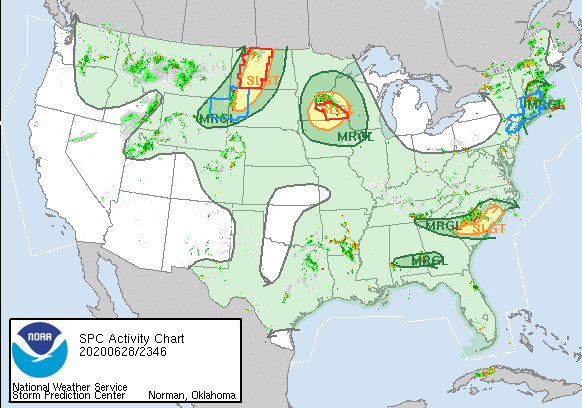
English: A 0100 UTC outlook map with tornado and severe thunderstorm watches as well as radar. There are five Marginal risk areas and three of them contain Slight risks as well. |
| Date | |
| Source | spc.noaa.gov |
| Author | Storm Prediction Center |
Licensing edit
This image is in the public domain because it was stored on the web servers of the U.S. Storm Prediction Center, which is part of National Weather Service. NWS-created images are automatically public domain in the U.S. since the NWS is a part of the U.S. government.
Thus all images on SPC servers are public domain. |
File history
Click on a date/time to view the file as it appeared at that time.
| Date/Time | Thumbnail | Dimensions | User | Comment | |
|---|---|---|---|---|---|
| current | 01:44, 29 June 2020 | | 582 × 408 (160 KB) | ChessEric (talk | contribs) | Uploaded a work by Storm Prediction Center from spc.noaa.gov with UploadWizard |
You cannot overwrite this file.
File usage on Commons
The following 2 pages use this file:
- User:ChessEric
- File:Activity loop 2.gif (file redirect)
File usage on other wikis
The following other wikis use this file:
- Usage on en.wikipedia.org
- Usage on www.wikidata.org