File:STS045-152-105 Southern Tip of Greenland.jpg

Size of this preview: 762 × 600 pixels. Other resolutions: 305 × 240 pixels | 610 × 480 pixels | 976 × 768 pixels | 1,280 × 1,008 pixels | 2,560 × 2,016 pixels | 5,136 × 4,044 pixels.
Original file (5,136 × 4,044 pixels, file size: 3.11 MB, MIME type: image/jpeg)
Captions
Captions
Add a one-line explanation of what this file represents
| Description |
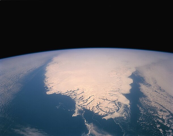
English: The southern tip of Greenland is seen in this high-oblique, almost colorless, stark photograph of the world’s largest island. The blackness of space contrasts sharply with the whiteness of clouds, ice, and snow. The only true color is the blue of the Atlantic Ocean and the Labrador Sea. Cloud-free conditions existing along the southern coastal area emphasize the deeply indented fjords along the coast. A close look at the white areas reveals three different features—snow and ice on the land; cloud formations over the central region and the eastern and western sides of the island; and wispy-looking ice floes off the southeast and the southwest tip of the fjord-lined coast, which are moved by the East Greenland Current to the south-southwest, and larger ice packs developing north along the east coast. Greenland has the only surviving continental glacier in the Northern Hemisphere. This ice sheet covers seven-eighths of Greenland’s surface and contains an estimated 11 percent of the world’s fresh water. |
|||||
| Date | ||||||
| Source | https://www.flickr.com/photos/29988733@N04/9361661572 | |||||
| Author | NASA | |||||
| Permission (Reusing this file) |
|

File history
Click on a date/time to view the file as it appeared at that time.
| Date/Time | Thumbnail | Dimensions | User | Comment | |
|---|---|---|---|---|---|
| current | 05:31, 16 March 2015 | | 5,136 × 4,044 (3.11 MB) | Jcpag2012 (talk | contribs) | Transferred from https://farm8.staticflickr.com/7350/9361661572_d749566886_o_d.jpg |
You cannot overwrite this file.
File usage on Commons
The following 2 pages use this file: