File:Sachem range map.png

Size of this preview: 800 × 370 pixels. Other resolutions: 320 × 148 pixels | 640 × 296 pixels | 1,357 × 628 pixels.
Original file (1,357 × 628 pixels, file size: 19 KB, MIME type: image/png)
Captions
Captions
Add a one-line explanation of what this file represents
Summary
edit
| Description |
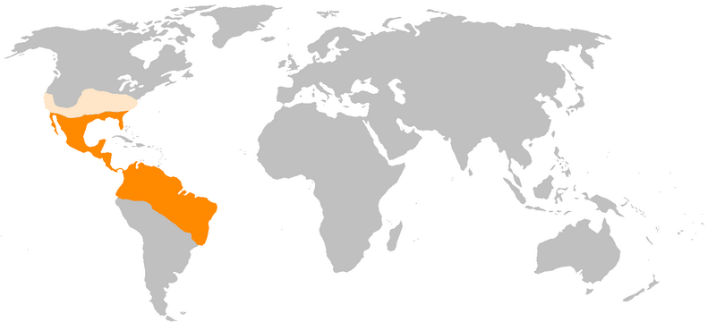
English: Range map for Sachem butterfly (Atalopedes campestris). |
| Date | |
| Source | Own work |
| Author | PopularOutcast |
Licensing
edit
I, the copyright holder of this work, hereby publish it under the following license:
This file is licensed under the Creative Commons Attribution-Share Alike 4.0 International license.
- You are free:
- to share – to copy, distribute and transmit the work
- to remix – to adapt the work
- Under the following conditions:
- attribution – You must give appropriate credit, provide a link to the license, and indicate if changes were made. You may do so in any reasonable manner, but not in any way that suggests the licensor endorses you or your use.
- share alike – If you remix, transform, or build upon the material, you must distribute your contributions under the same or compatible license as the original.
File history
Click on a date/time to view the file as it appeared at that time.
| Date/Time | Thumbnail | Dimensions | User | Comment | |
|---|---|---|---|---|---|
| current | 12:53, 10 September 2018 | | 1,357 × 628 (19 KB) | PopularOutcast (talk | contribs) | Corrected the southern part of range based on additional information. American/English books did not detail which South American countries this butterfly existed in, only that it occurred south to Brazil. This website lists countries for this species http://www.bio-nica.info/Ento/Lepido/HESPERIIDAE.htm. |
| 03:40, 10 September 2018 |  | 1,357 × 628 (19 KB) | PopularOutcast (talk | contribs) | User created page with UploadWizard |
You cannot overwrite this file.
File usage on Commons
There are no pages that use this file.
File usage on other wikis
The following other wikis use this file:
- Usage on ceb.wikipedia.org
- Usage on en.wikipedia.org