File:Sakha Republic - administrative divisions numbered.svg

Size of this PNG preview of this SVG file: 598 × 600 pixels. Other resolutions: 239 × 240 pixels | 479 × 480 pixels | 766 × 768 pixels | 1,021 × 1,024 pixels | 2,042 × 2,048 pixels | 702 × 704 pixels.
Original file (SVG file, nominally 702 × 704 pixels, file size: 119 KB)
Captions
Captions
Add a one-line explanation of what this file represents
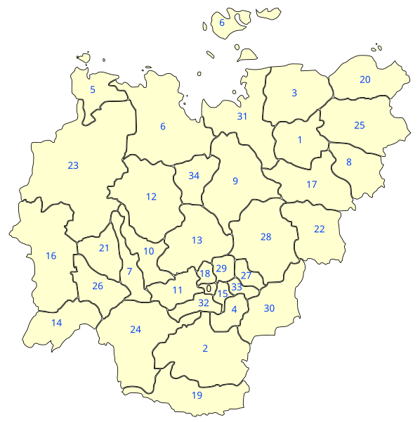
| Description | Map of the uluses of Sakha Republic. Non-contiguous parts of uluses have been grouped together and each ulus (and New Siberian Islands) has been id-tagged with it's name. |
| Date | (UTC) |
| Source | |
| Author |
|
| This is a retouched picture, which means that it has been digitally altered from its original version. Modifications: numbered version (see ru:Файл:Sakha_Republic_Municipal_Divisions.PNG. The original can be viewed here: Sakha Republic - administrative divisions.svg:
|
I, the copyright holder of this work, hereby publish it under the following license:
This file is licensed under the Creative Commons Attribution-Share Alike 2.5 Generic license.
- You are free:
- to share – to copy, distribute and transmit the work
- to remix – to adapt the work
- Under the following conditions:
- attribution – You must give appropriate credit, provide a link to the license, and indicate if changes were made. You may do so in any reasonable manner, but not in any way that suggests the licensor endorses you or your use.
- share alike – If you remix, transform, or build upon the material, you must distribute your contributions under the same or compatible license as the original.
Original upload log edit
This image is a derivative work of the following images:
- File:Sakha_Republic_-_administrative_divisions.svg licensed with Cc-by-sa-2.5
- 2008-04-16T18:26:55Z Lokal Profil 702x704 (111541 Bytes) {{Information |Description=Map of the uluses of Sakha Republic. The [[:en:New Siberian Islands]] have a different coulour to indicate that they are not part of any ulus instead it is a natural reserve zone directly under juri
Uploaded with derivativeFX
File history
Click on a date/time to view the file as it appeared at that time.
| Date/Time | Thumbnail | Dimensions | User | Comment | |
|---|---|---|---|---|---|
| current | 15:57, 4 August 2009 | | 702 × 704 (119 KB) | Katpatuka (talk | contribs) | {{Information |Description=Map of the uluses of Sakha Republic. Non-contiguous parts of uluses have been grouped together and each ulus (and New Siberian Islands) has been id-tagged with it's name. |Source=*[[:File:Sakha_Republic_-_administrative_division |
You cannot overwrite this file.
File usage on Commons
There are no pages that use this file.
File usage on other wikis
The following other wikis use this file:
- Usage on fr.wikipedia.org
- Usage on gl.wikipedia.org
- Usage on nl.wikipedia.org