File:SaltRiverMap.jpg
No higher resolution available.
SaltRiverMap.jpg (800 × 600 pixels, file size: 329 KB, MIME type: image/jpeg)
Captions
Captions
Add a one-line explanation of what this file represents
| Description |
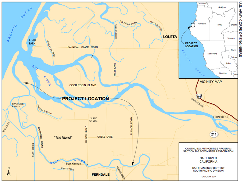
English: Map of Salt River in Humboldt County California prepared by the U.S. Army Corps of Engineers for the Section 206 ecosystem restoration project underway in 2013 and 2014. The map is dated January 14, 2014, although it was issued in October of 2013. |
||||||
| Date | |||||||
| Source | U.S. Army Corps of Engineers | ||||||
| Author | U.S. Army Corps of Engineers | ||||||
| Permission (Reusing this file) |
|
||||||

| Object location | | View this and other nearby images on: OpenStreetMap |
|---|
File history
Click on a date/time to view the file as it appeared at that time.
| Date/Time | Thumbnail | Dimensions | User | Comment | |
|---|---|---|---|---|---|
| current | 01:36, 23 October 2013 | | 800 × 600 (329 KB) | Ellin Beltz (talk | contribs) | Fixed location of town "Loleta" and "Riverside Ranch" which were a bit out of location. Added labels for SR211, Fernbridge and Eel River Drive. |
| 20:07, 21 October 2013 |  | 993 × 737 (448 KB) | Ellin Beltz (talk | contribs) | {{Information |Description ={{en|1=Map of Salt River in Humboldt County California prepared by the U.S. Army Corps of Engineers for the Section 206 ecosystem restoration project underway in 2013 and 2014. The map is dated January 14, 2014, although... |
You cannot overwrite this file.
File usage on Commons
There are no pages that use this file.
File usage on other wikis
The following other wikis use this file:
- Usage on en.wikipedia.org