File:Salt mining in germany.png
Size of this preview: 506 × 600 pixels. Other resolutions: 202 × 240 pixels | 405 × 480 pixels | 648 × 768 pixels | 864 × 1,024 pixels | 2,000 × 2,371 pixels.
Original file (2,000 × 2,371 pixels, file size: 549 KB, MIME type: image/png)
Captions
Captions
Add a one-line explanation of what this file represents
Summary edit
| Description |
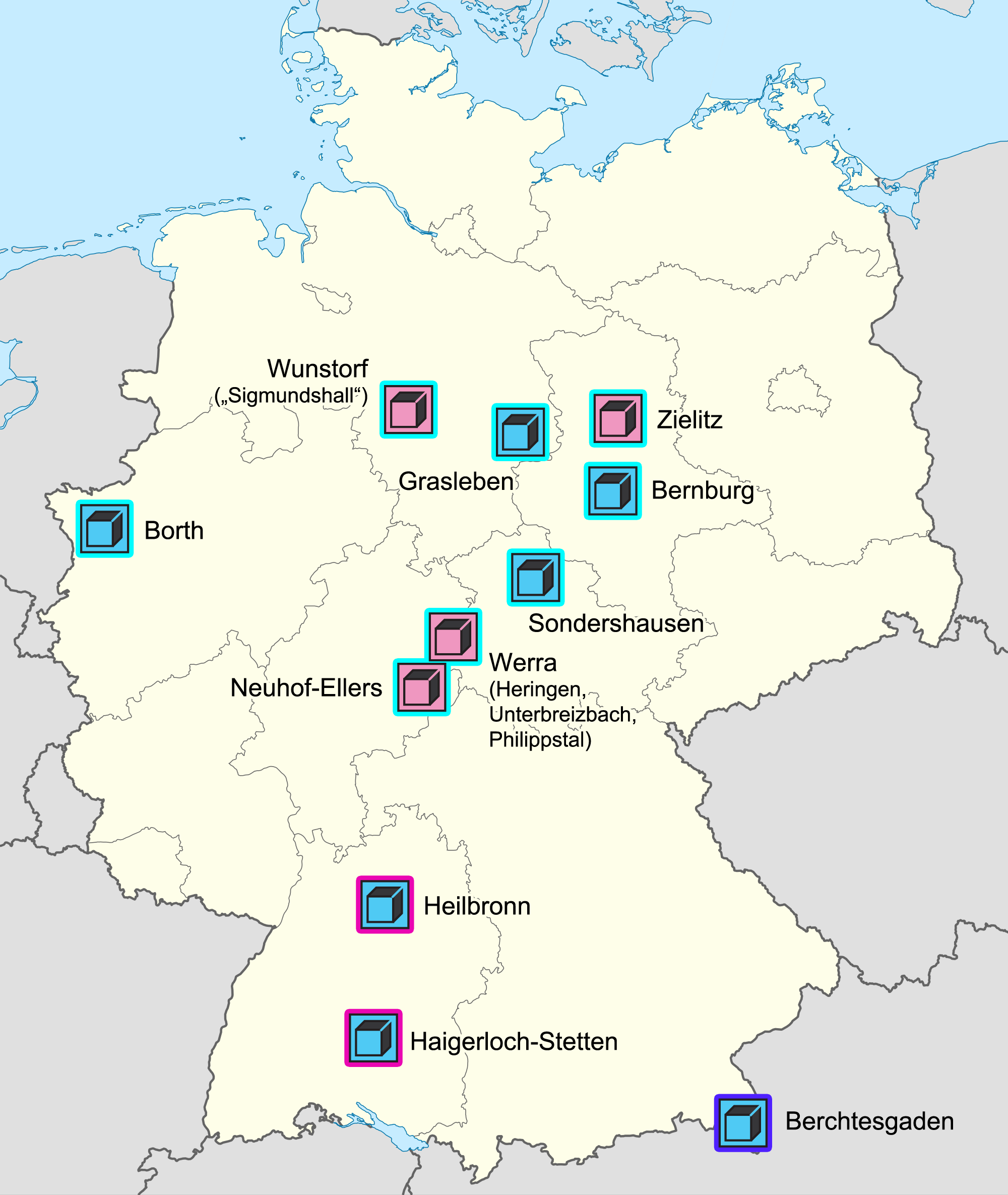
Deutsch: Salzbergwerke in Deutschland.
Bedeutung der Symbole: Rosa=Kalibergwerk, blau=Steinsalzbergwerk; Bedeutung der Rahmenfarben=Ursprungshorizont: Hellblau=Zechstein (Oberperm), dunkelpink=Mittlerer Muschelkalk (Mitteltrias), lila=alpine Permotrias
English: Salt mines in Germany.
Meaning of symbols: light pink=potash mine, blue=rock salt mine; meaning of frame colour=source level: light blue=Zechstein (Upper Permian), dark pink=middle Muschelkalk (Middle Triassic), violet=alpine Permotriassic
Français : Mines de sel en Allemagne.
Sens des symboles: rose=mine de potasse, bleu=mine de halite; sens des couleurs de cadre=niveau d'origine: bleu clair=Zechstein (Permien supérieur), rose foncé=Muschelkalk moyen (Trias moyen), violet=Permotrias alpin |
| Date | (UTC) |
| Source |
This file was derived from: Germany location map.svg:  |
| Author |
|
| This is a retouched picture, which means that it has been digitally altered from its original version. The original can be viewed here: Germany location map.svg:
|
Licensing edit
I, the copyright holder of this work, hereby publish it under the following licenses:
This file is licensed under the Creative Commons Attribution-Share Alike 3.0 Unported license.
- You are free:
- to share – to copy, distribute and transmit the work
- to remix – to adapt the work
- Under the following conditions:
- attribution – You must give appropriate credit, provide a link to the license, and indicate if changes were made. You may do so in any reasonable manner, but not in any way that suggests the licensor endorses you or your use.
- share alike – If you remix, transform, or build upon the material, you must distribute your contributions under the same or compatible license as the original.

|
Permission is granted to copy, distribute and/or modify this document under the terms of the GNU Free Documentation License, Version 1.2 or any later version published by the Free Software Foundation; with no Invariant Sections, no Front-Cover Texts, and no Back-Cover Texts. A copy of the license is included in the section entitled GNU Free Documentation License. |
You may select the license of your choice.
Original upload log edit
This image is a derivative work of the following images:
- File:Germany_location_map.svg licensed with Cc-by-sa-3.0, GFDL
- 2012-10-02T12:32:40Z Palosirkka 1073x1272 (463006 Bytes) Reverted to version as of 20:14, 5 August 2012 Location maps must remain very accurate
- 2012-10-02T05:40:12Z Palosirkka 1073x1272 (405944 Bytes) Scrubbed with http://codedread.com/scour/
- 2012-08-05T20:14:30Z NordNordWest 1073x1272 (463006 Bytes) upd
- 2010-01-19T10:03:29Z NordNordWest 1073x1272 (502104 Bytes) update
- 2009-07-22T08:33:33Z NordNordWest 1075x1273 (623082 Bytes) c
- 2008-10-13T14:36:44Z NordNordWest 1075x1273 (620685 Bytes)
- 2008-10-09T21:13:47Z NordNordWest 1075x1273 (627868 Bytes) smaller file, data optimized
- 2008-06-30T20:25:05Z NordNordWest 1076x1274 (899543 Bytes) {{Information |Description= {{de|Positionskarte von [[:de:Deutschland|Deutschland]]}} Quadratische Plattkarte, N-S-Streckung 150 %. Geographische Begrenzung der Karte: * N: 55.1° N * S: 47.2° N * W: 5.5° O * O: 15.5° O {{
Uploaded with derivativeFX
File history
Click on a date/time to view the file as it appeared at that time.
| Date/Time | Thumbnail | Dimensions | User | Comment | |
|---|---|---|---|---|---|
| current | 05:53, 20 March 2013 | | 2,000 × 2,371 (549 KB) | Gretarsson (talk | contribs) | == {{int:filedesc}} == {{Information |Description={{de|Salzbergwerke in Deutschland. Bedeutung der Symbole: Rosa=Kalibergwerk, blau=Steinsalzbergwerk; Bedeutung der Rahmenfarben=Ursprungshorizont: Hellblau=Zechstein (Oberperm), dunk... |
You cannot overwrite this file.
File usage on Commons
The following page uses this file:
File usage on other wikis
The following other wikis use this file:
- Usage on de.wikipedia.org