File:Salty plain in Bolivia.jpg

Original file (1,676 × 1,676 pixels, file size: 1.77 MB, MIME type: image/jpeg)
Captions
Captions
Summary
edit
| Salty plain in Bolivia | |
|---|---|
| Photographer |
Envisat satellite |
| Title |
Salty plain in Bolivia |
| Description |
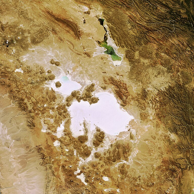
English: This Envisat image features salt flats in the Department of Potosi in southwest Bolivia, near the crest of the Andes Mountains.
The Salar de Uyuni (the lower white area) is the largest salt flat in the world, occupying 10 582 sq km. It is located at the southern end of the Altiplano, a high plain of inland drainage in the central Andes. Some 40 000 years ago, this area was part of a giant prehistoric lake that dried out, leaving behind two salt flats, the Uyuni and the Salar de Coipasa (visible above Uyuni), as well as two modern lakes, Poopó (visible in green) and Uru Uru. Occupying 2218 sq km, Salar de Coipasa is Bolivia's second largest salt flat. Stretching 90 km in length and 32 km in width, Lake Poopó is the country's second largest lake with the permanent part of its body covering approximately 1000 sq km. This image was acquired by Envisat’s Medium Resolution Imaging Spectrometer (MERIS) instrument on 7 May 2008 working in Full Resolution mode to provide a spatial resolution of 300 m. |
| Depicted place | Bolivia |
| Date | 7 May 2008 |
| Collection | European Space Agency |
| Accession number |
239593 |
| Credit line | ESA |
| Source | http://www.esa.int/spaceinimages/Images/2008/05/Salty_plain_in_Bolivia |
Licensing
edit
- You are free:
- to share – to copy, distribute and transmit the work
- to remix – to adapt the work
- Under the following conditions:
- attribution – You must give appropriate credit, provide a link to the license, and indicate if changes were made. You may do so in any reasonable manner, but not in any way that suggests the licensor endorses you or your use.
- share alike – If you remix, transform, or build upon the material, you must distribute your contributions under the same or compatible license as the original.
File history
Click on a date/time to view the file as it appeared at that time.
| Date/Time | Thumbnail | Dimensions | User | Comment | |
|---|---|---|---|---|---|
| current | 10:12, 7 March 2017 | | 1,676 × 1,676 (1.77 MB) | Revent (talk | contribs) | =={{int:filedesc}}== {{Photograph |photographer = Envisat satellite |title = Salty plain in Bolivia |description = {{en|1=This Envisat image features salt flats in the Department of Potosi in southwest Bolivia, near the cre... |
You cannot overwrite this file.
File usage on Commons
The following 4 pages use this file:
File usage on other wikis
The following other wikis use this file:
- Usage on zh.wikipedia.org