File:Santa Fe ray system (THEMIS thermal inertia map).png

Size of this preview: 600 × 600 pixels. Other resolutions: 240 × 240 pixels | 480 × 480 pixels | 768 × 768 pixels | 1,024 × 1,024 pixels | 1,420 × 1,420 pixels.
Original file (1,420 × 1,420 pixels, file size: 1.43 MB, MIME type: image/png)
Captions
Captions
Add a one-line explanation of what this file represents
Summary edit
.png&action=edit§ion=1)
| Description |
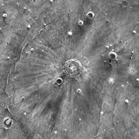
Українська: Карта теплової інерції (чим вища, тим світліше) околиць марсіанського кратера Санта-Фе. Сам кратер (розташований у центрі зображення) має діаметр 20,3 км. Навколо нього видно численні темні та світлі промені, які (на відміну від звичайних променів кратерів) могли бути створені надзвуковими струменями пари (Schultz, Quintana, 2017).
English: Map of thermal inertia (the more inertia, the brighter image) of the neighbourhood of Martian crater Santa Fe. The crater (in the centre) is 20.3 km in diameter. It is surrounded by a system of dark and bright rays, which (unlike usual crater rays) could be created by supersonic jets of vapour (Schultz, Quintana, 2017). |
| Date | |
| Source | THEMIS Thermal Inertia 100m Global Mosaic |
| Author | NASA (infrared images of THEMIS camera onboard 2001 Mars Odyssey) |
Licensing edit
.png&action=edit§ion=2)
| This file is in the public domain in the United States because it was solely created by NASA. NASA copyright policy states that "NASA material is not protected by copyright unless noted". (See Template:PD-USGov, NASA copyright policy page or JPL Image Use Policy.) | ||
 |
Warnings:
|
File history
Click on a date/time to view the file as it appeared at that time.
| Date/Time | Thumbnail | Dimensions | User | Comment | |
|---|---|---|---|---|---|
| current | 23:39, 16 January 2018 | | 1,420 × 1,420 (1.43 MB) | Sneeuwschaap (talk | contribs) | User created page with UploadWizard |
You cannot overwrite this file.
File usage on Commons
The following 2 pages use this file:
File usage on other wikis
The following other wikis use this file:
- Usage on it.wikipedia.org
- Usage on ru.wikipedia.org
- Usage on www.wikidata.org
.png&oldid=446717026)