File:Santos basin map.png

Size of this preview: 800 × 492 pixels. Other resolutions: 320 × 197 pixels | 640 × 394 pixels | 990 × 609 pixels.
Original file (990 × 609 pixels, file size: 550 KB, MIME type: image/png)
Captions
Captions
Add a one-line explanation of what this file represents
Summary edit
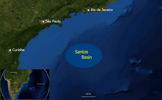
| Description | Map of the Santos Basin oil producing region off the coast of Brazil |
| Date | |
| Source | Own work |
| Author | Mmm |
Background image is from NASA World Wind, which is public domain.
Size and location derived from from http://www2.petrobras.com.br/ri/pdf/2007_Formigli_Miami_pre-sal.pdf Pre-Salt Reservoirs Offshore Brazil: Perspectives and Challenges.
Licensing edit
| I, the copyright holder of this work, release this work into the public domain. This applies worldwide. In some countries this may not be legally possible; if so: I grant anyone the right to use this work for any purpose, without any conditions, unless such conditions are required by law. |
File history
Click on a date/time to view the file as it appeared at that time.
| Date/Time | Thumbnail | Dimensions | User | Comment | |
|---|---|---|---|---|---|
| current | 23:18, 17 February 2008 | | 990 × 609 (550 KB) | Mmm~commonswiki (talk | contribs) | {{Information |Description=Map of the Santos Basin oil producing region off the coast of Brazil |Source=self-made |Date=Feb 17, 2008 |Author= Mmm |Permission= |other_versions= }} Background image is from NASA World Wind, which is public |
You cannot overwrite this file.
File usage on Commons
There are no pages that use this file.
File usage on other wikis
The following other wikis use this file:
- Usage on ca.wikipedia.org
- Usage on en.wikipedia.org
- Usage on es.wikipedia.org
- Usage on pt.wikipedia.org