File:Satellite picture of the Amazon River.jpg

Original file (1,000 × 581 pixels, file size: 213 KB, MIME type: image/jpeg)
Captions
Captions
Summary edit
| Description |
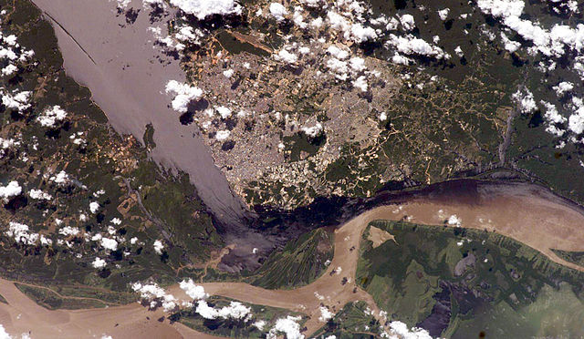
English: Satellite picture of the Amazon River, near the city of Manaus, capital of the state of Amazonas, northen Brazil.
Português: Imagem de satélite do Rio Amazonas, próximo a cidade de Manaus, capital do estado do Amazonas, norte do Brasil.
Original caption — The largest river on the planet, the Amazon, forms from the confluence of the Solimões (the upper Amazon River) and the Negro at the Brazilian city of Manaus in central Amazonas. At the river conjunction, the muddy, tan-colored waters of the Solimões meet the "black" water of the Negro River. The unique mixing zone where the waters meet extends downstream through the rainforest for hundreds of miles, and attracts tourists from all over the world, which has contributed to substantial growth in the city of Manaus. It is the vast quantity of sediment eroded from the Andes Mountains that gives the Solimões its tan color. By comparison, water in the Negro derives from the low jungles where reduced physical erosion of rock precludes mud entering the river. In place of sediment, organic matter from the forest floor stains the river the color of black tea. The Solimões provides nutrient-rich mud to lakes on the floodplain (lower right). The ecology of muddy lakes differs correspondingly from that of nutrient-poor, blackwater rivers and lakes. Solimões water can be seen leaking into the Negro west of the main meeting zone (lower left). The Solimões is much shallower than the Negro because it has filled its valley and bed with great quantities of sediment since the valleys were excavated. Widths of the rivers differ for this reason. |
| Date | 13 July 2006 |
| Source | NASA (Image galleries) |
| Author | National Aeronautics and Space Administration (NASA) |
Licensing edit
| This file is in the public domain in the United States because it was solely created by NASA. NASA copyright policy states that "NASA material is not protected by copyright unless noted". (See Template:PD-USGov, NASA copyright policy page or JPL Image Use Policy.) | ||
 |
Warnings:
|
File history
Click on a date/time to view the file as it appeared at that time.
| Date/Time | Thumbnail | Dimensions | User | Comment | |
|---|---|---|---|---|---|
| current | 02:50, 14 July 2006 | | 1,000 × 581 (213 KB) | Felipe Menegaz (talk | contribs) | {{Information| |Description= The largest river on the planet, the Amazon, forms from the confluence of the Solimões (the upper Amazon River) and the Negro at the Brazilian city of Manaus in central Amazonas. At the river conjunction, the muddy, tan-color |
You cannot overwrite this file.
File usage on Commons
The following 3 pages use this file:
File usage on other wikis
The following other wikis use this file:
- Usage on azb.wikipedia.org
- Usage on ml.wikipedia.org
- Usage on mwl.wikipedia.org
- Usage on sk.wikipedia.org
- Usage on www.wikidata.org