File:Savannah, 1779 RCIN 734052.jpg

Original file (2,000 × 1,574 pixels, file size: 1.08 MB, MIME type: image/jpeg)
Captions
Captions
Summary edit
| Description |
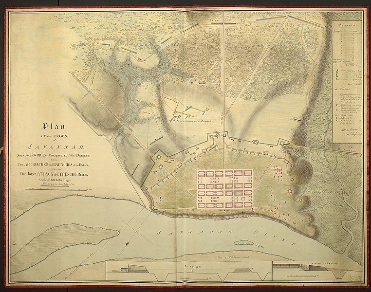
English: A plan of Savannah showing the defence works and the works of the enemy 9 October 1779. American War of Independence (1775-83). Oriented with south-east to top.
Manuscript title: Plan OF the TOWN of SAVANNAH, SHEWING the WORKS CONSTRUCTED for its DEFENCE: Likewise THE APPROACHES and BATTERIES of the ENEMY, Together with THE JOINT ATTACK of the FRENCH & REBELS On the 9.th October 1779. [left centre] Insets: [bottom centre, a section through the fortification.] Scale: 1:121 approx. Scale bar: [75 mm =] 30 Feet. Size: 5.2 x 44.1 cm (neatline). [Bottom right:] SECTION of a REDOUBT. Scale: 1:120 approx. [76 mm =] 30 Feet. Size: 5.3 x 23.8 cm (neatline). Additional text: [right, in plain rectangular cartouche, a key, 1-14, to the batteries and the number of guns in each, the numbers of pieces of field artillery, the numbers of French guns, a symbol for the Rebel 'Galleys' [ships], and, A-I, K, to other military features. A note reads: 'The works Coloured Green were finished before the Summons and the other works during the Siege':] REFERENCE. A fair drawn plan showing the positions of the French encampments and batteries, and those of the British, during the siege of Savannah, 4-9 October 1779. Savannah had been captured by the British, under the command of Lieutenant-Colonel Archibald Campbell in 1778, and the British remained in control of the town until July 1782. The siege had begun with a bombardment from the river and land on 4 October and the final assault was repulsed on 9 October, the date of the situation of this map. This plan is signed by James Moncrief, the Chief Engineer at the siege, but it is possible that the signature was merely to confirm the authenticity of the content of the plan rather than to indicate that he drew it. Another manuscript example of this plan is in the British Library, Add. MS. 57716.3 which was exhibited as item 134 in the British Library's exhibition 'The American War of Independence 1775-1784' in London, 1975. From a Survey by John Wilson 71.st Reg.t A[ssistant] Engineer. Draughtsman signed: James Moncrief Comd.g Engineer. George III catalogue entry: Savannah A drawn Plan of the Town of Savannah, shewing the Works constructed for its defence, likewise the Approaches & Batteries of the Enemy, together with the joint Attack of the French & Rebels on the 9.th of October 1779: by James Moncrief, commanding Engineer. |
| Date | |
| Source | https://militarymaps.rct.uk/american-war-of-independence-1775-83/savannah-1779-plan-of-the-town-of-savannah |
| Author |
James Moncrief (1744-93) (draughtsman) John Wilson (active 1779-80) surveyor |
Licensing edit
|
This is a faithful photographic reproduction of a two-dimensional, public domain work of art. The work of art itself is in the public domain for the following reason:
The official position taken by the Wikimedia Foundation is that "faithful reproductions of two-dimensional public domain works of art are public domain".
This photographic reproduction is therefore also considered to be in the public domain in the United States. In other jurisdictions, re-use of this content may be restricted; see Reuse of PD-Art photographs for details. | ||||
File history
Click on a date/time to view the file as it appeared at that time.
| Date/Time | Thumbnail | Dimensions | User | Comment | |
|---|---|---|---|---|---|
| current | 10:19, 1 August 2021 | | 2,000 × 1,574 (1.08 MB) | Broichmore (talk | contribs) | Uploaded a work by James Moncrief (1744-93) (draughtsman) John Wilson (active 1779-80) surveyor from https://militarymaps.rct.uk/american-war-of-independence-1775-83/savannah-1779-plan-of-the-town-of-savannah with UploadWizard |
You cannot overwrite this file.
File usage on Commons
The following page uses this file: