File:Schachtanlagen Worthlah-Ohlendorf.jpg

Size of this preview: 491 × 599 pixels. Other resolutions: 196 × 240 pixels | 584 × 713 pixels.
Original file (584 × 713 pixels, file size: 112 KB, MIME type: image/jpeg)
Captions
Captions
Add a one-line explanation of what this file represents
Summary edit
| Description |
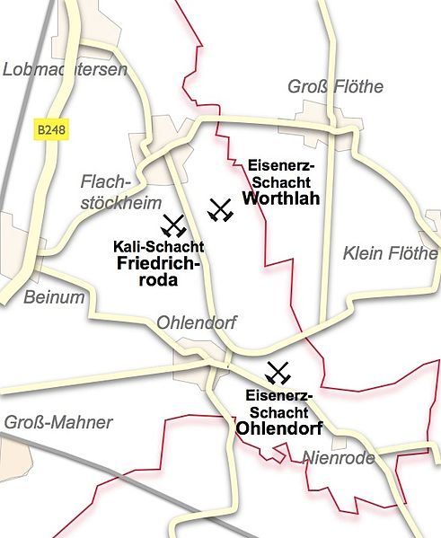
Deutsch: Karte der Schachtanlagen Friedrichroda (Kali), Worthlah und Ohlendorf (beide Eisenerz). Anmerkungen:Die Karte zeigt die Lage der Schachtanlagen des Kaliwerkes Friedrichroda und der Eisenerzgruben Worthlah und Ohlendorf in den Gemarkungen von Salzgitter-Flachstöckheim und Salzgitter-Ohlendorf. Um eine Orientierung zu erleichtern, wurde dem Plan eine aktuelle Straßenkarte unterlegt. |
| Date | |
| Source | Own work (Original text: eigene Arbeit) |
| Author | Johamar 06:28, 7. Dez. 2010 (CET) |
Licensing edit

|
Permission is granted to copy, distribute and/or modify this document under the terms of the GNU Free Documentation License, Version 1.2 or any later version published by the Free Software Foundation; with no Invariant Sections, no Front-Cover Texts, and no Back-Cover Texts. A copy of the license is included in the section entitled GNU Free Documentation License. |
This file is licensed under the Creative Commons Attribution-Share Alike 3.0 Unported license.
- You are free:
- to share – to copy, distribute and transmit the work
- to remix – to adapt the work
- Under the following conditions:
- attribution – You must give appropriate credit, provide a link to the license, and indicate if changes were made. You may do so in any reasonable manner, but not in any way that suggests the licensor endorses you or your use.
- share alike – If you remix, transform, or build upon the material, you must distribute your contributions under the same or compatible license as the original.
This file is licensed under the Creative Commons Attribution-Share Alike 3.0 Germany license.
- You are free:
- to share – to copy, distribute and transmit the work
- to remix – to adapt the work
- Under the following conditions:
- attribution – You must give appropriate credit, provide a link to the license, and indicate if changes were made. You may do so in any reasonable manner, but not in any way that suggests the licensor endorses you or your use.
- share alike – If you remix, transform, or build upon the material, you must distribute your contributions under the same or compatible license as the original.

Original upload log edit
Transferred from de.wikipedia to Commons by Ireas using CommonsHelper.
The original description page was here. All following user names refer to de.wikipedia.
- 2010-12-07 09:02 Johamar 584×713× (115139 bytes) {{Information |Beschreibung = |Quelle = |Urheber = |Datum = |Genehmigung = |Andere Versionen = |Anmerkungen = }}
- 2010-12-07 08:58 Johamar 1280×720× (141510 bytes) {{Information |Beschreibung = |Quelle = |Urheber = |Datum = |Genehmigung = |Andere Versionen = |Anmerkungen = }}
- 2010-12-07 05:28 Johamar 593×714× (115725 bytes) {{Information |Beschreibung = Karte der Schachtanlagen Friedrichhall (Kali), Worthlah und Ohlendorf (beide Eisenerz) |Quelle = eigene Arbeit |Urheber = ~~~~ |Datum = 2010-12-07 |Genehmigung = |Andere Versionen = |A
File history
Click on a date/time to view the file as it appeared at that time.
| Date/Time | Thumbnail | Dimensions | User | Comment | |
|---|---|---|---|---|---|
| current | 01:11, 8 December 2010 | | 584 × 713 (112 KB) | File Upload Bot (Magnus Manske) (talk | contribs) | {{BotMoveToCommons|de.wikipedia|year={{subst:CURRENTYEAR}}|month={{subst:CURRENTMONTHNAME}}|day={{subst:CURRENTDAY}}}} {{Information |Description={{de|Karte der Schachtanlagen Friedrichroda (Kali), Worthlah und Ohlendorf (beide Eisenerz)}} |Source=Transf |
You cannot overwrite this file.
File usage on Commons
The following page uses this file:
File usage on other wikis
The following other wikis use this file:
- Usage on de.wikipedia.org
- Usage on www.wikidata.org