File:Schaduwzone aardbevingsgolf.svg

Size of this PNG preview of this SVG file: 379 × 509 pixels. Other resolutions: 179 × 240 pixels | 357 × 480 pixels | 572 × 768 pixels | 762 × 1,024 pixels | 1,525 × 2,048 pixels.
Original file (SVG file, nominally 379 × 509 pixels, file size: 224 KB)
Captions
Captions
Add a one-line explanation of what this file represents
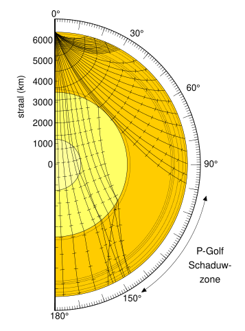
| Description | Raypaths of S- and P-waves through the Earth's mantle and core |
| Date | (UTC) |
| Source | |
| Author |
|
| This is a retouched picture, which means that it has been digitally altered from its original version. Modifications: translated English words into Dutch. The original can be viewed here: Earthquake wave shadow zone.gif:
|
This image is in the public domain in the United States because it only contains materials that originally came from the United States Geological Survey, an agency of the United States Department of the Interior. For more information, see the official USGS copyright policy.
|
Original upload log edit
This image is a derivative work of the following images:
- Image:Earthquake_wave_shadow_zone.gif licensed with PD-USGov-USGS
- 2007-03-26T15:41:24Z Woudloper 330x483 (20541 Bytes) {{Information |Description=Raypaths of S- and P-waves through the Earth's mantle and core |Source=Original image could be found at http://earthquake.usgs.gov/image_glossary/shadow_zone.html |Date= |Author=USGS |Permission={{P
Uploaded with derivativeFX
File history
Click on a date/time to view the file as it appeared at that time.
| Date/Time | Thumbnail | Dimensions | User | Comment | |
|---|---|---|---|---|---|
| current | 17:13, 16 September 2008 | | 379 × 509 (224 KB) | Lies Van Rompaey (talk | contribs) | {{Information |Description=Raypaths of S- and P-waves through the Earth's mantle and core |Source=*Image:Earthquake_wave_shadow_zone.gif |Date=2008-09-16 17:06 (UTC) |Author=*derivative work: ~~~ *Image:Earthquake_wave_shadow_zone.gif: USGS |P |
You cannot overwrite this file.
File usage on Commons
There are no pages that use this file.
File usage on other wikis
The following other wikis use this file:
- Usage on da.wikipedia.org