File:Schleswig-Holstein map.PNG
Size of this preview: 389 × 600 pixels. Other resolutions: 156 × 240 pixels | 311 × 480 pixels | 763 × 1,176 pixels.
Original file (763 × 1,176 pixels, file size: 131 KB, MIME type: image/png)
Captions
Captions
Add a one-line explanation of what this file represents
| Description |
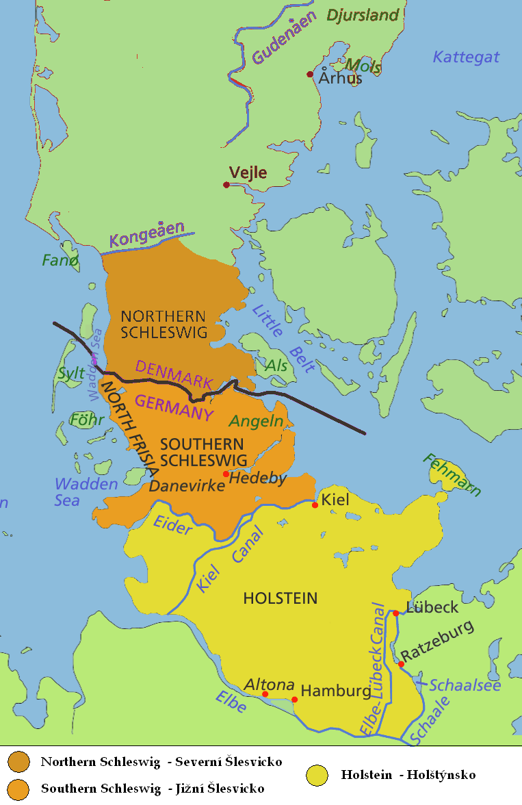
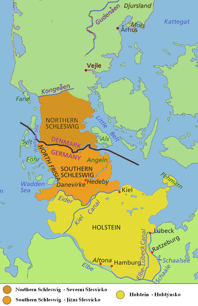
English: Map of Jutland Peninsula
Southern Jutland (Sønderjylland in Danish) or Northern Schleswig (Nordschleswig in German): Danish since 1920; part of the Duchy of Schleswig until 1864; German from 1864 until 1920
Southern Schleswig (German since 1864; part of the Duchy of Schleswig until 1864; formerly considered part of Southern Jutland)
Historical area of Holstein, sometimes considered part of Jutland Peninsula - south to the Elbe and the Elbe-Lübeck Canal
Deutsch: Karte der Halbinsel Jütland/Cimbrische Halbinsel
Nordschleswig, dänisch Sønderjylland (Südjütland): Herzogtum Schleswig bis 1864, Deutschland 1864 bis 1920, Dänemark seit 1920
Südschleswig (bis 1920 als Teil Südjütlands betrachtet): Herzogtum Schleswig bis 1864, Deutschland seit 1864
Historisches Gebiet von Holstein, manchmal als Teil der Halbinsel Jütland angesehen - südlich bis zur Elbe und dem Elbe-Lübeck-Kanal
Čeština: Mapa Jutského poloostrova
Jižní Jutsko, Severní Schleswig (Sønderjylland, Nordslesvig)
Jižní Schleswig
Historický Holstein |
| Date | (UTC) |
| Source | |
| Author |
|
| This is a retouched picture, which means that it has been digitally altered from its original version. Modifications: map only of Schleswig-Hostein region, in english and czech. The original can be viewed here: Jutland Peninsula map.PNG:
|
I, the copyright holder of this work, hereby publish it under the following licenses:
This file is licensed under the Creative Commons Attribution-Share Alike 2.5 Generic, 2.0 Generic and 1.0 Generic license.
- You are free:
- to share – to copy, distribute and transmit the work
- to remix – to adapt the work
- Under the following conditions:
- attribution – You must give appropriate credit, provide a link to the license, and indicate if changes were made. You may do so in any reasonable manner, but not in any way that suggests the licensor endorses you or your use.
- share alike – If you remix, transform, or build upon the material, you must distribute your contributions under the same or compatible license as the original.
| This file is licensed under the Creative Commons Attribution-Share Alike 3.0 Unported license. | ||
| ||
| This licensing tag was added to this file as part of the GFDL licensing update. |

|
Permission is granted to copy, distribute and/or modify this document under the terms of the GNU Free Documentation License, Version 1.2 or any later version published by the Free Software Foundation; with no Invariant Sections, no Front-Cover Texts, and no Back-Cover Texts. A copy of the license is included in the section entitled GNU Free Documentation License. |
You may select the license of your choice.
Original upload log edit
This image is a derivative work of the following images:
- File:Jutland_Peninsula_map.PNG licensed with Cc-by-sa-2.5,2.0,1.0, Cc-by-sa-3.0-migrated, GFDL
- 2008-04-23T10:22:18Z PhJ 964x1741 (145790 Bytes) {{Information |Description= |Source= |Date= |Author= |Permission= |other_versions= }}
- 2006-05-04T07:46:11Z Roke 964x1741 (120421 Bytes) schaale schaalsee
- 2006-04-29T03:27:54Z Roke 964x1741 (118906 Bytes) Altona position
- 2006-04-29T03:21:29Z Roke 964x1741 (118899 Bytes) wadden sea, nordstrand border, extend yellow to Schalle and Ratzeburg, +Altona, +Helgoland
- 2006-04-27T00:20:44Z Roke 964x1741 (115442 Bytes) nordstrand
- 2006-04-27T00:15:11Z Roke 964x1741 (115380 Bytes) same colour from border to Eider river
- 2006-04-26T01:22:06Z Valentinian 964x1741 (137475 Bytes) Fixed Nordstrand
- 2006-04-25T12:45:35Z Roke 964x1741 (116408 Bytes) moved dannevirke north
- 2006-04-25T05:30:35Z Roke 964x1741 (116169 Bytes) deleted a layer i shouldnt have
- 2006-04-25T05:26:17Z Roke 964x1741 (114293 Bytes) minor fix of eider, kiel canal
- 2006-04-25T05:02:03Z Roke 964x1741 (116502 Bytes) eider, wadden sea, hedeby
- 2006-04-17T06:17:25Z Roke 964x1741 (116712 Bytes) Map of Jutland Peninsula [[Category:Denmark]]
Uploaded with derivativeFX
File history
Click on a date/time to view the file as it appeared at that time.
| Date/Time | Thumbnail | Dimensions | User | Comment | |
|---|---|---|---|---|---|
| current | 16:17, 2 August 2009 | | 763 × 1,176 (131 KB) | Kolomaznik (talk | contribs) | {{Information |Description= |Source=*File:Jutland_Peninsula_map.PNG |Date=2009-08-02 16:15 (UTC) |Author=*File:Jutland_Peninsula_map.PNG: Roke *derivative work: ~~~ |Permission=see below |other_versions= }} {{RetouchedPicture|map only of Sch |
You cannot overwrite this file.
File usage on Commons
The following page uses this file:
- File:Schleswig-Hostein map.PNG (file redirect)
File usage on other wikis
The following other wikis use this file:
- Usage on ca.wikipedia.org
- Usage on cs.wikipedia.org
- Usage on fi.wikipedia.org
- Usage on fr.wiktionary.org
- Usage on ja.wikipedia.org
- Usage on zh.wikipedia.org