File:Scientology Trementina Sub.jpg
Size of this preview: 800 × 418 pixels. Other resolutions: 320 × 167 pixels | 893 × 467 pixels.
Original file (893 × 467 pixels, file size: 131 KB, MIME type: image/jpeg)
Captions
Captions
Add a one-line explanation of what this file represents
Summary edit
| Description |
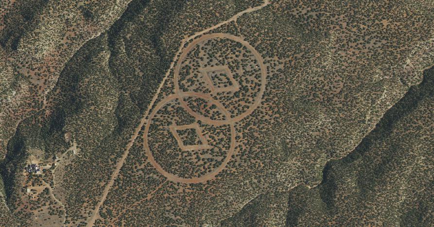
English: Satellite photo of Scientology "Trementina base", with diamonds-in-intersecting-circles symbol. |
| Date | 15 February 2022 (upload date) |
| Source |
Aerial imagery taken from USDA's National Agriculture Imagery Program USDA 1m digital ortho layer Excerpted detail of Image:Scientology Trementina.jpg to show notable terrain feature. |
| Author | USDA |
| Other versions |
|


Licensing edit
This work is in the public domain in the United States because it is a work prepared by an officer or employee of the United States Government as part of that person’s official duties under the terms of Title 17, Chapter 1, Section 105 of the US Code.
Note: This only applies to original works of the Federal Government and not to the work of any individual U.S. state, territory, commonwealth, county, municipality, or any other subdivision. This template also does not apply to postage stamp designs published by the United States Postal Service since 1978. (See § 313.6(C)(1) of Compendium of U.S. Copyright Office Practices). It also does not apply to certain US coins; see The US Mint Terms of Use.
|
 | |
| This file has been identified as being free of known restrictions under copyright law, including all related and neighboring rights. | ||
Original upload log edit
The original description page was here. All following user names refer to en.wikipedia.
- 2008-03-09 03:26 AndroidCat 200×123× (25113 bytes) [[NASA World Wind]] [[USGS]] 1m digital ortho layer worldwind://goto/world=Earth&lat=35.51432&lon=-104.57757&alt=5638 Sub-section of [[:Image:Scientology Trementina.jpg]] to show notable terrain feature.
File history
Click on a date/time to view the file as it appeared at that time.
| Date/Time | Thumbnail | Dimensions | User | Comment | |
|---|---|---|---|---|---|
| current | 21:34, 15 February 2022 | | 893 × 467 (131 KB) | 9yz (talk | contribs) | New NAIP color imagery from 2020 |
| 16:02, 21 May 2011 |  | 200 × 123 (25 KB) | File Upload Bot (Magnus Manske) (talk | contribs) | {{BotMoveToCommons|en.wikipedia|year={{subst:CURRENTYEAR}}|month={{subst:CURRENTMONTHNAME}}|day={{subst:CURRENTDAY}}}} {{Information |Description={{en|en:NASA World Wind en:USGS 1m digital ortho layer worldwind://goto/world=Earth&lat=35.514 |
You cannot overwrite this file.
File usage on Commons
The following page uses this file:
File usage on other wikis
The following other wikis use this file:
- Usage on en.wikipedia.org
- Usage on www.wikidata.org