File:Scotland land cover map-en.svg

Size of this PNG preview of this SVG file: 415 × 599 pixels. Other resolutions: 166 × 240 pixels | 333 × 480 pixels | 532 × 768 pixels | 710 × 1,024 pixels | 1,420 × 2,048 pixels | 2,090 × 3,015 pixels.
Original file (SVG file, nominally 2,090 × 3,015 pixels, file size: 1.27 MB)
Captions
Captions
Add a one-line explanation of what this file represents
Summary edit
| Description |
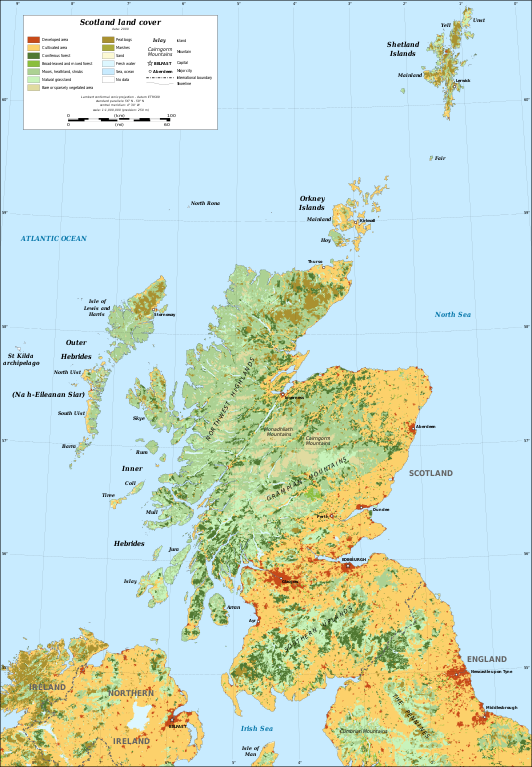
English: Map in English of Scotland's land cover, year 2000.
Note: the background map is a raster image embedded in the SVG file. Français : Carte en anglais de la couverture du sol de l'Écosse, année 2000. Note : le fond de carte est une image bitmap embarquée dans le fichier SVG.
|
||
| Date | |||
| Source |
Own work
|
||
| Author | Eric Gaba (Sting - fr:Sting) | ||
| Permission (Reusing this file) |
|
||
| Other versions |
|


| Camera location | | View this and other nearby images on: OpenStreetMap |
|---|

|
This SVG file contains embedded text that can be translated into your language, using any capable SVG editor, text editor or the SVG Translate tool. For more information see: About translating SVG files. |
Licensing edit
Eric Gaba (Wikimedia Commons user Sting) and the European Environment Agency, the copyright holder of this work, hereby publishes it under the following license:
This file is licensed under the Creative Commons Attribution-Share Alike 3.0 Unported license.
Attribution: Eric Gaba (Wikimedia Commons user Sting) and the European Environment Agency
- You are free:
- to share – to copy, distribute and transmit the work
- to remix – to adapt the work
- Under the following conditions:
- attribution – You must give appropriate credit, provide a link to the license, and indicate if changes were made. You may do so in any reasonable manner, but not in any way that suggests the licensor endorses you or your use.
- share alike – If you remix, transform, or build upon the material, you must distribute your contributions under the same or compatible license as the original.
File history
Click on a date/time to view the file as it appeared at that time.
| Date/Time | Thumbnail | Dimensions | User | Comment | |
|---|---|---|---|---|---|
| current | 19:10, 28 December 2010 | | 2,090 × 3,015 (1.27 MB) | Sting (talk | contribs) | == {{int:filedesc}} == {{Information |Description={{en|Map in English of Scotland's land cover, year 2000.<br/> ''Note: the background map is a raster image embedded in the SVG file.''}} {{fr|Carte en anglais de la [[:f |
You cannot overwrite this file.
File usage on Commons
The following 5 pages use this file:
File usage on other wikis
The following other wikis use this file:
- Usage on en.wikipedia.org