File:Sea Ice off Russia (MODIS 2022-04-07).jpg

Original file (6,020 × 4,814 pixels, file size: 3.6 MB, MIME type: image/jpeg)
Captions
Captions
Summary edit
.jpg&action=edit§ion=1)
| Description |
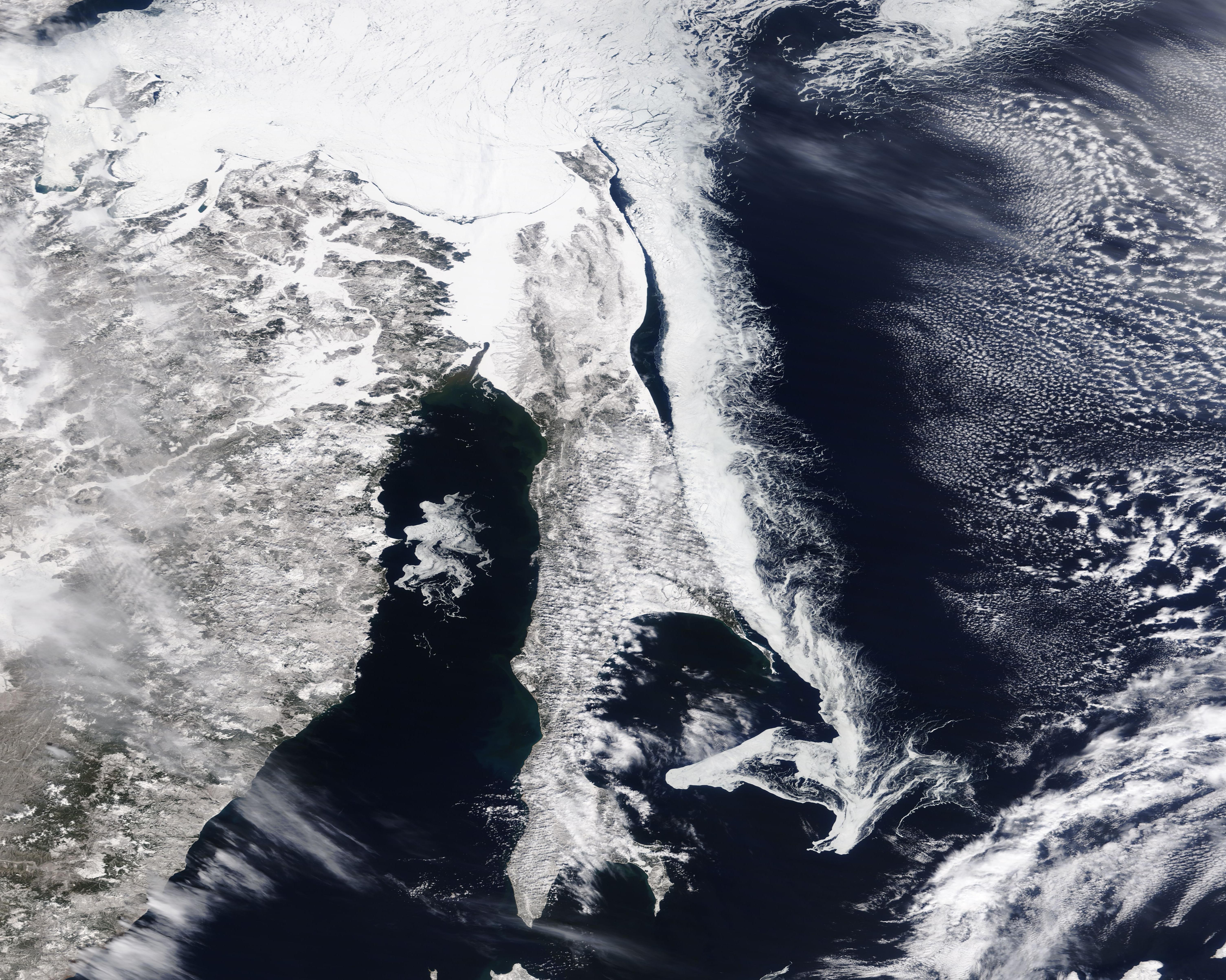
English: Sea ice and snow dominated the landscape of Russia’s Far East in early April 2022. The Moderate Resolution Imaging Spectroradiometer (MODIS) on board NASA’s Terra satellite acquired a true-color image of the early spring scene on April 2.
In the north, fast ice clings to the coast of Khabarovsk Krai in many locations, but large fractures can also be seen near the coastline and across the northern reach of the Strait of Tartary. Further north, the sea ice over the Sea of Okhotsk shows many fractures, both large and small—a sure sign that melting is well underway. A large river of sea ice sits off the east coast of Sakhalin Island. On the eastern side, this sea ice thins and curls into delicate-appearing filigrees while the southern end of the river of ice expands into eddies and swirls. This dense collection of ice sits above the East Sakhalin Current, which runs towards Japan’s Hokkaido Island. The current, which typically begins to wane in April, typically carries winter’s ice towards northern Japan. A swirl of floating sea ice sits in the southern Tartary Strait between Sakhalin Island and mainland Russia. The northern portion of the Tartary Strait appears to remain solidly frozen, with few fissures or cracks visible. Warming temperatures and lengthening daylight usually cause sea ice to begin to melt rapidly over the Sea of Okhotsk during the month of April. However, according to the National Snow and Ice Data Center (NSIDC), the sea ice extent was below average in the Sea of Okhotsk through the months of February and March 2022. Indeed, on April 5, the NSIDC reported, “Average Arctic sea ice extent for March 2022 was 14.59 million square kilometers (5.63 million square miles), ranking ninth lowest in the satellite record...The 2022 March extent was 840,000 square kilometers (324,000 square miles) below the 1981 to 2010 average. While extent tracked below the interdecile range of the satellite record throughout the entire month, the total decline, after a series of small ups and downs, was only 250,000 square kilometers (96,500 square miles).” |
||
| Date | Taken on 2 April 2022 | ||
| Source |
Sea Ice off Russia (direct link)
|
||
| Author | MODIS Land Rapid Response Team, NASA GSFC |
| This media is a product of the Terra mission Credit and attribution belongs to the mission team, if not already specified in the "author" row |
Licensing edit
.jpg&action=edit§ion=2)
| This file is in the public domain in the United States because it was solely created by NASA. NASA copyright policy states that "NASA material is not protected by copyright unless noted". (See Template:PD-USGov, NASA copyright policy page or JPL Image Use Policy.) | ||
 |
Warnings:
|
File history
Click on a date/time to view the file as it appeared at that time.
| Date/Time | Thumbnail | Dimensions | User | Comment | |
|---|---|---|---|---|---|
| current | 22:09, 9 January 2024 | | 6,020 × 4,814 (3.6 MB) | OptimusPrimeBot (talk | contribs) | #Spacemedia - Upload of http://modis.gsfc.nasa.gov/gallery/images/image04072022_250m.jpg via Commons:Spacemedia |
You cannot overwrite this file.
File usage on Commons
There are no pages that use this file.
.jpg&oldid=852758036)