File:SerbiaEn1913.svg

Size of this PNG preview of this SVG file: 443 × 600 pixels. Other resolutions: 177 × 240 pixels | 354 × 480 pixels | 567 × 768 pixels | 756 × 1,024 pixels | 1,513 × 2,048 pixels | 492 × 666 pixels.
Original file (SVG file, nominally 492 × 666 pixels, file size: 1.4 MB)
Captions
Captions
Add a one-line explanation of what this file represents
| Description |
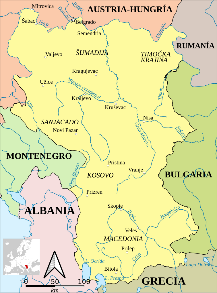
Español: Fronteras de Serbia en 1913, tras la Segunda Guerra Balcánica.
English: Serbia in 1913, after the territorial gains of the Second Balkan War.
Català: Sèrbia el 1913, després dels guanys territorials de la Segona Guerra Balcànica. |
| Date | (UTC) |
| Source | |
| Author |
|
| This is a retouched picture, which means that it has been digitally altered from its original version. Modifications: Turned into SVG and translated into Spanish. The original can be viewed here: Serbia1913.png:
|
This file is licensed under the Creative Commons Attribution-Share Alike 3.0 Unported license.
- You are free:
- to share – to copy, distribute and transmit the work
- to remix – to adapt the work
- Under the following conditions:
- attribution – You must give appropriate credit, provide a link to the license, and indicate if changes were made. You may do so in any reasonable manner, but not in any way that suggests the licensor endorses you or your use.
- share alike – If you remix, transform, or build upon the material, you must distribute your contributions under the same or compatible license as the original.
Original upload log edit
This image is a derivative work of the following images:
- File:Serbia1913.png licensed with PD-user
- 2010-01-18T00:09:19Z Bidgee 659x910 (58762 Bytes) I'll allow the new version
- 2010-01-18T00:03:07Z Bidgee 582x831 (18205 Bytes) Reverted to version as of 21:38, 21 December 2006 While the image does expand on the original please do not upload over it, upload the improved map under a new name.
- 2010-01-16T20:30:30Z PANONIAN 659x910 (58762 Bytes) improved version
- 2006-12-21T21:38:44Z Electionworld 582x831 (18205 Bytes) {{ew|en|PANONIAN}} Self-made map by [[user:PANONIAN|PANONIAN]] {{PD-user|PANONIAN}} [[Category:Maps of Serbia]]
Uploaded with derivativeFX
File history
Click on a date/time to view the file as it appeared at that time.
| Date/Time | Thumbnail | Dimensions | User | Comment | |
|---|---|---|---|---|---|
| current | 11:04, 7 February 2021 | | 492 × 666 (1.4 MB) | Rowanwindwhistler (talk | contribs) | New version. EPSG3857 Projection. Rivers, sea & main borders from Natural Earth. Town locations from Openstreetmap. Main border corrections from: Map of Bulgaria after Treaty of Neuilly-sur-Seinе-bg.svg (Ikonact) Montenegro territory expanded (1830-1944).png (Пакко) Corrections may be needed for the Albanian-Serbian border (being defined at the time) and the Austro-Romanian one. |
| 22:28, 7 December 2019 |  | 683 × 925 (251 KB) | Rowanwindwhistler (talk | contribs) | Corrected | |
| 22:17, 7 December 2019 |  | 683 × 925 (476 KB) | Rowanwindwhistler (talk | contribs) | Slight changes | |
| 13:46, 27 July 2019 |  | 683 × 925 (247 KB) | Joutbis (talk | contribs) | File uploaded using svgtranslate tool (http://tools.wmflabs.org/svgtranslate/). Added translation for ca. | |
| 09:11, 23 April 2017 |  | 683 × 925 (232 KB) | Rowanwindwhistler (talk | contribs) | Fake text added | |
| 09:46, 30 April 2016 |  | 641 × 867 (79 KB) | Rowanwindwhistler (talk | contribs) | https://en.wikipedia.org/wiki/Wikipedia:WikiProject_Maps/Conventions | |
| 22:00, 9 September 2010 |  | 641 × 867 (81 KB) | Rowanwindwhistler (talk | contribs) | {{Information |Description={{es|1=Fronteras de Serbia en 1913, tras la Segunda Guerra Balcánica.}} {{en|1=Serbia in 1913, after the territorial gains of the Second Balkan War.}} |Source=*File:Serbia1913.png |Date=2010-09-09 22:00 (UTC) |Author=*[[: |
You cannot overwrite this file.
File usage on Commons
The following 3 pages use this file:
File usage on other wikis
The following other wikis use this file:
- Usage on ast.wikipedia.org
- Usage on ca.wikipedia.org
- Usage on de.wikipedia.org
- Usage on es.wikipedia.org
- Usage on mt.wikipedia.org