File:Sh2-Tafel im Gleis.jpg

Size of this preview: 800 × 533 pixels. Other resolutions: 320 × 213 pixels | 640 × 427 pixels | 1,024 × 683 pixels | 1,280 × 853 pixels | 1,536 × 1,024 pixels.
Original file (1,536 × 1,024 pixels, file size: 2.24 MB, MIME type: image/jpeg)
Captions
Captions
Add a one-line explanation of what this file represents
Summary
edit
| Description |
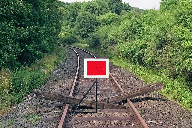
Deutsch: Seit Mai 2002 in Höhe Streckenkilometer 21,800 hinter dem Gleisanschluss montierte Schlusstafel. Diese Tafel wird überall dort aufgestellt, wo für den dahinterliegenden Streckenteil die Betriebsgenehmigung erloschen ist. Sichtbares Resultat eines Stilllegungsverfahrens. Es muss jedoch nicht bedeuten, dass unmittelbar dahinter der Schienenweg physikalisch endet. Unbefugten Dritten ist das Betreten von Bahnanlagen nicht gestattet. |
| Date | Summer 2009 |
| Source | Self-photographed (Original text: selbst fotographiert) |
| Author | Ferres |
| Permission (Reusing this file) |
Deutsch: es wird ausdrücklich auf die hier unten unter -Lizenz- enthaltenen Angaben verwiesen |
| Other versions |
Deutsch: zurzeit auch bei https://www.youtube.com/user/Lumdatalbahn als User/Hintergrundbild |
| Object location | | View this and other nearby images on: OpenStreetMap |
|---|
Licensing
edit
This file is licensed under the Creative Commons Attribution-Share Alike 3.0 Germany license.
Attribution: Ferres
- You are free:
- to share – to copy, distribute and transmit the work
- to remix – to adapt the work
- Under the following conditions:
- attribution – You must give appropriate credit, provide a link to the license, and indicate if changes were made. You may do so in any reasonable manner, but not in any way that suggests the licensor endorses you or your use.
- share alike – If you remix, transform, or build upon the material, you must distribute your contributions under the same or compatible license as the original.

Original upload log
edit
The original description page was here. All following user names refer to de.wikipedia.
- 2012-01-14 12:16 Ferres 1536×1024× (2348824 bytes) {{Information |Beschreibung = seit Mai 2002 in Höhe Streckenkilometer 21,800 hinter dem Gleisanschluss montierte Schlusstafel |Quelle = selbst fotographiert |Urheber = ~~~~ |Datum = Sommer 2009 |Genehmigung = |Ande
File history
Click on a date/time to view the file as it appeared at that time.
| Date/Time | Thumbnail | Dimensions | User | Comment | |
|---|---|---|---|---|---|
| current | 05:16, 23 January 2012 | | 1,536 × 1,024 (2.24 MB) | File Upload Bot (Magnus Manske) (talk | contribs) | {{BotMoveToCommons|de.wikipedia|year={{subst:CURRENTYEAR}}|month={{subst:CURRENTMONTHNAME}}|day={{subst:CURRENTDAY}}}} {{Information |Description={{de|seit Mai 2002 in Höhe Streckenkilometer 21,800 hinter dem Gleisanschluss montierte Schlusstafel}} |Sou |
You cannot overwrite this file.
File usage on Commons
The following page uses this file:
- File:-Sh2-Tafel im Gleis.jpg (file redirect)
File usage on other wikis
The following other wikis use this file:
- Usage on de.wikipedia.org