File:Shackleton South Georgia Crossing map-fr.svg

Size of this PNG preview of this SVG file: 775 × 500 pixels. Other resolutions: 320 × 206 pixels | 640 × 413 pixels | 1,024 × 661 pixels | 1,280 × 826 pixels | 2,560 × 1,652 pixels.
Original file (SVG file, nominally 775 × 500 pixels, file size: 758 KB)
Captions
Captions
Add a one-line explanation of what this file represents
Summary edit
| Description |
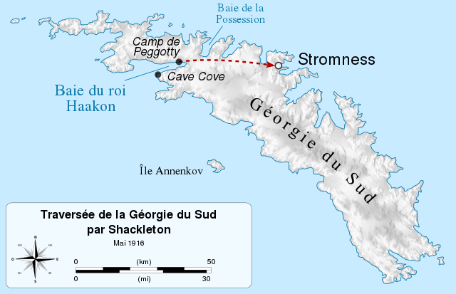
English: Map of the Shackleton's crossing of South Georgia in may 1916, during the Imperial Trans-Antarctic Expedition.
Shackleton's journey Français : Carte de la traversée de la Géorgie du Sud par Ernest Shackleton en mai 1916, lors de l'expédition Endurance.
Trajet de Shackleton |
| Date | |
| Source |
|
| Author | |
| Attribution (required by the license) | © Sémhur / Wikimedia Commons / |
| SVG development |
| Object location | | View this and other nearby images on: OpenStreetMap |
|---|
Licensing edit
I, the copyright holder of this work, hereby publish it under the following licenses:
| Copyleft: This work of art is free; you can redistribute it and/or modify it according to terms of the Free Art License. You will find a specimen of this license on the Copyleft Attitude site as well as on other sites. |
This file is licensed under the Creative Commons Attribution-Share Alike 4.0 International, 3.0 Unported, 2.5 Generic, 2.0 Generic and 1.0 Generic license.
- You are free:
- to share – to copy, distribute and transmit the work
- to remix – to adapt the work
- Under the following conditions:
- attribution – You must give appropriate credit, provide a link to the license, and indicate if changes were made. You may do so in any reasonable manner, but not in any way that suggests the licensor endorses you or your use.
- share alike – If you remix, transform, or build upon the material, you must distribute your contributions under the same or compatible license as the original.
You may select the license of your choice.
File history
Click on a date/time to view the file as it appeared at that time.
| Date/Time | Thumbnail | Dimensions | User | Comment | |
|---|---|---|---|---|---|
| current | 13:13, 18 March 2015 | | 775 × 500 (758 KB) | Sémhur (talk | contribs) | == {{int:filedesc}} == {{Information |Description= {{en|1= Map of the Shackleton's crossing of South Georgia in may 1916, during the Imperial Trans-Antarctic Expedition. {{Legend||line=3px dashed #b00000|Shac... |
You cannot overwrite this file.
File usage on Commons
The following 2 pages use this file:
File usage on other wikis
The following other wikis use this file: