File:Shakemap Earthquake 24 Aug 2016 Myanmar.jpg

Size of this preview: 511 × 600 pixels. Other resolutions: 204 × 240 pixels | 612 × 718 pixels.
Original file (612 × 718 pixels, file size: 133 KB, MIME type: image/jpeg)
Captions
Captions
Add a one-line explanation of what this file represents
Summary
edit
| Description |
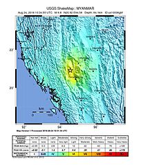
한국어: 2016년 차우크 지진의 진도 지도.
English: 2016 25km W of Chauk, Burma earthquake map |
| Date | |
| Source | https://earthquake.usgs.gov/earthquakes/eventpage/us10006gbf#shakemap |
| Author | United States Geological Survey |
Licensing
edit
This image is in the public domain in the United States because it only contains materials that originally came from the United States Geological Survey, an agency of the United States Department of the Interior. For more information, see the official USGS copyright policy.
|
File history
Click on a date/time to view the file as it appeared at that time.
| Date/Time | Thumbnail | Dimensions | User | Comment | |
|---|---|---|---|---|---|
| current | 11:51, 24 August 2016 | | 612 × 718 (133 KB) | Twotwo2019 (talk | contribs) | User created page with UploadWizard |
You cannot overwrite this file.
File usage on Commons
There are no pages that use this file.
File usage on other wikis
The following other wikis use this file:
- Usage on cs.wikipedia.org
- Usage on en.wikipedia.org
- Usage on fr.wikipedia.org
- Usage on id.wikipedia.org
- Usage on it.wikipedia.org
- Usage on ja.wikipedia.org
- Usage on ko.wikipedia.org
- Usage on th.wikipedia.org
- Usage on www.wikidata.org
- Usage on xmf.wikipedia.org
- Usage on zh.wikipedia.org