File:Shinkansen map 20110312 en.png
Size of this preview: 581 × 600 pixels. Other resolutions: 232 × 240 pixels | 465 × 480 pixels | 744 × 768 pixels | 992 × 1,024 pixels | 1,984 × 2,048 pixels | 3,100 × 3,200 pixels.
Original file (3,100 × 3,200 pixels, file size: 370 KB, MIME type: image/png)
Captions
Captions
Add a one-line explanation of what this file represents
Summary edit
| Description |
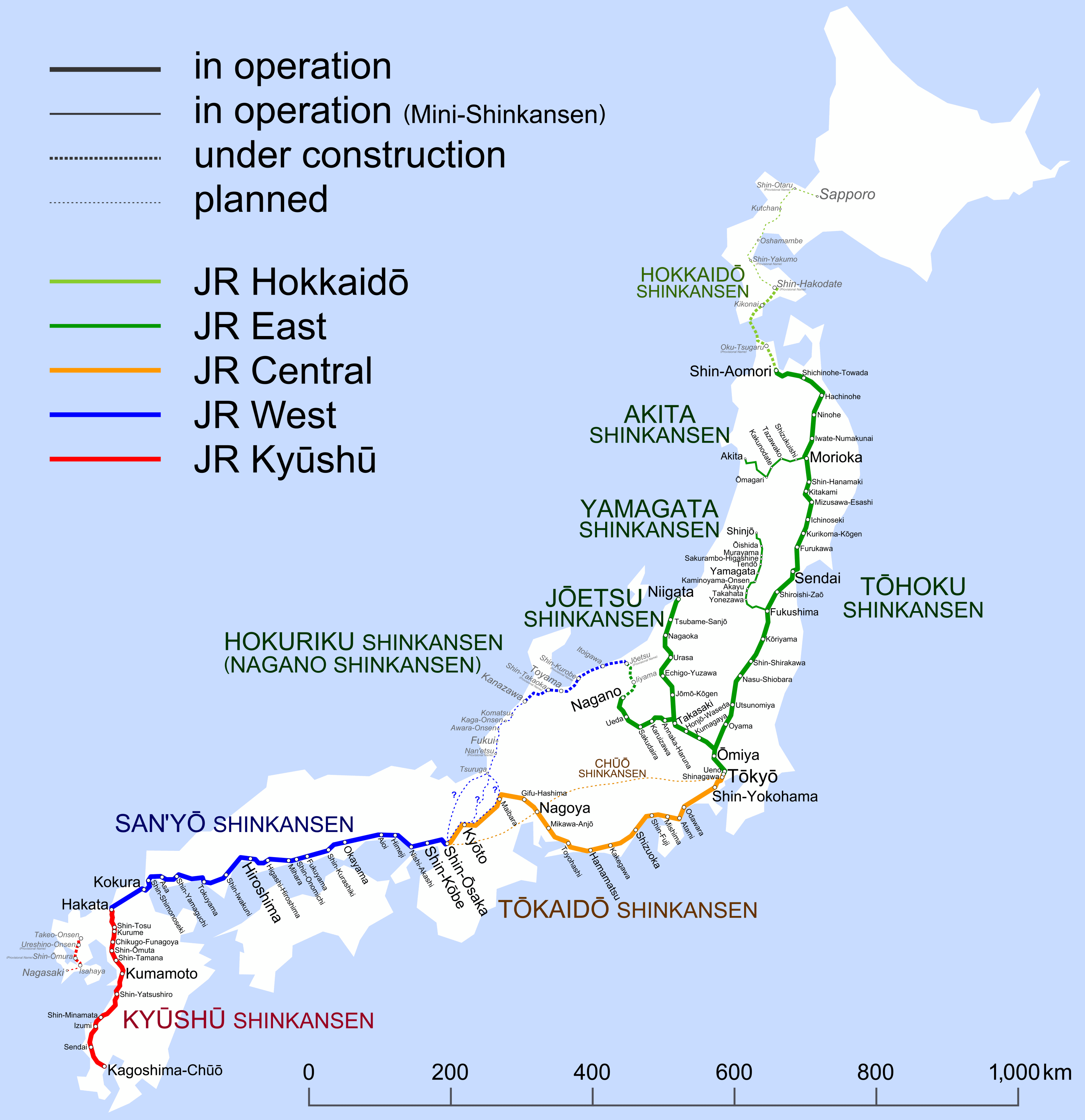
English: Map of Shinkansen network. (2011-03-12 – ) |
||||||||||||||||||||||||||||||||
| Date | |||||||||||||||||||||||||||||||||
| Source | Own work | ||||||||||||||||||||||||||||||||
| Author | Hisagi (氷鷺) | ||||||||||||||||||||||||||||||||
| Other versions |
|
Licensing edit
I, the copyright holder of this work, hereby publish it under the following licenses:
This file is licensed under the Creative Commons Attribution-Share Alike 3.0 Unported license.
- You are free:
- to share – to copy, distribute and transmit the work
- to remix – to adapt the work
- Under the following conditions:
- attribution – You must give appropriate credit, provide a link to the license, and indicate if changes were made. You may do so in any reasonable manner, but not in any way that suggests the licensor endorses you or your use.
- share alike – If you remix, transform, or build upon the material, you must distribute your contributions under the same or compatible license as the original.

|
Permission is granted to copy, distribute and/or modify this document under the terms of the GNU Free Documentation License, Version 1.2 or any later version published by the Free Software Foundation; with no Invariant Sections, no Front-Cover Texts, and no Back-Cover Texts. A copy of the license is included in the section entitled GNU Free Documentation License. |
You may select the license of your choice.
File history
Click on a date/time to view the file as it appeared at that time.
| Date/Time | Thumbnail | Dimensions | User | Comment | |
|---|---|---|---|---|---|
| current | 17:06, 27 February 2012 | | 3,100 × 3,200 (370 KB) | Karl432 (talk | contribs) | Reverted to version as of 23:19, 7 March 2011. The "removal of distracting diacritics from English names" is erroneous, as this does not take into account that the file is used for articles in several other languages. Also, the names in the map are not... |
| 01:51, 11 December 2011 |  | 3,100 × 3,200 (386 KB) | DAJF (talk | contribs) | Removal of distracting diacritics (macrons) from English names | |
| 23:19, 7 March 2011 |  | 3,100 × 3,200 (370 KB) | Hisagi (talk | contribs) | Ōyama→Oyama | |
| 02:27, 6 March 2011 |  | 3,100 × 3,200 (361 KB) | Hisagi (talk | contribs) | {{Information |Description ={{en|1=Map of Shinkansen network. (after March 12, 2011) }} |Source ={{own}} |Author =Hisagi (氷鷺) |Date =2011-03-05 |Permission = |other_versions = }} [ |
You cannot overwrite this file.
File usage on Commons
There are no pages that use this file.
File usage on other wikis
The following other wikis use this file:
- Usage on ru.wikipedia.org