File:Siege of Ostend, 1745 RCIN 729001.i.jpg

Original file (2,000 × 1,413 pixels, file size: 1.59 MB, MIME type: image/jpeg)
Captions
Captions
Summary edit
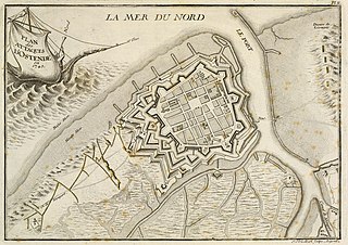
| Français : PLAN des ATTAQUES D'OSTENDE en 1745.
( |
|||||||||||||||||||||
|---|---|---|---|---|---|---|---|---|---|---|---|---|---|---|---|---|---|---|---|---|---|
| Artist |
Jean-Geoffrey Striedbeck (1707-72) (engraver), Pierre du Mortous (active 1750s) (author), ? P de Lormel (active 1759-93) (publisher) |
||||||||||||||||||||
| Title |
Français : PLAN des ATTAQUES D'OSTENDE en 1745. |
||||||||||||||||||||
| Description |
English: A map of the siege of Ostend in 1745, showing in yellow the French approach works during the siege. War of the Austrian Succession (1740-48). Oriented with north-north-west to top (compass direction is indicated by the dog on the figurehead of the ship the title cartouche).
From: l'Histoire des Conquêtes de LOUIS XV. by Pierre Du Mortous: Paris, de Lormel, 1759. This plate is one of 24 siege plans, stitched together with the general index map (RCIN 729001.a) at the beginning.
|
||||||||||||||||||||
| Depicted place | Ostend, Flanders, Belgium (51°13'24"N 02°54'42"E) | ||||||||||||||||||||
| Date | circa 1759 | ||||||||||||||||||||
| Medium | etching and engraving | ||||||||||||||||||||
| Dimensions | Scale: 1:8,850 approx. Scale bar: [22 mm =] 100 Toises.; 20.7 x 29.7 cm (neatline); 21.8 x 30.2 cm (image); 22.2 x 31.0 cm (platemark); 24.5 x 39.9 cm (sheet) | ||||||||||||||||||||
| Collection |
|
||||||||||||||||||||
| Accession number |
RCIN 729001.i |
||||||||||||||||||||
| Source/Photographer | https://militarymaps.rct.uk/war-of-the-austrian-succession-1740-8/siege-of-ostend-1745-plan-des-attaques | ||||||||||||||||||||
| Other versions |
|
||||||||||||||||||||

Licensing edit
|
This is a faithful photographic reproduction of a two-dimensional, public domain work of art. The work of art itself is in the public domain for the following reason:
The official position taken by the Wikimedia Foundation is that "faithful reproductions of two-dimensional public domain works of art are public domain".
This photographic reproduction is therefore also considered to be in the public domain in the United States. In other jurisdictions, re-use of this content may be restricted; see Reuse of PD-Art photographs for details. | ||||
File history
Click on a date/time to view the file as it appeared at that time.
| Date/Time | Thumbnail | Dimensions | User | Comment | |
|---|---|---|---|---|---|
| current | 14:53, 20 July 2021 | | 2,000 × 1,413 (1.59 MB) | Broichmore (talk | contribs) | {{Artwork |artist = Jean-Geoffrey Striedbeck (1707-72) (engraver), Pierre du Mortous (active 1750s) (author), ? P de Lormel (active 1759-93) (publisher) |author = |title = {{fr|1=PLAN des ATTAQUES D'OSTENDE en 1745.}} |description = {{en|1=A map of the siege of Ostend in 1745, showing in yellow the French approach works during the siege. War of the Austrian Succession (1740-48). Oriented with north-north-west to top (compass direction is indicated... |
You cannot overwrite this file.
File usage on Commons
The following page uses this file:
File usage on other wikis
The following other wikis use this file:
- Usage on en.wikipedia.org
- Usage on fr.wikipedia.org