File:Siegen Aussicht Oberes Schloss Schlosspark.jpg

Size of this preview: 800 × 324 pixels. Other resolutions: 320 × 130 pixels | 640 × 259 pixels | 1,024 × 415 pixels | 1,280 × 519 pixels | 2,960 × 1,200 pixels.
Original file (2,960 × 1,200 pixels, file size: 1.35 MB, MIME type: image/jpeg)
Captions
Captions
Add a one-line explanation of what this file represents
Summary edit
| Description |
|
| Date | (ISO 8601) |
| Source | self-made by author |
| Author | Bob Ionescu |
| Permission (Reusing this file) |
Deutsch: Dieses Bild ist urheberrechtlich geschützt. Der Urheber gestattet jedermann unter der Bedingung der angemessenen Nennung seiner Urheberschaft - Namensnennung (z.B. Foto: Bob Ionescu in der Bildunterschrift) jegliche Nutzung dieser Datei (Einräumung eines einfachen Nutzungsrechts). Weiterverbreitung, Bearbeitung und kommerzielle Nutzung sind gestattet. Der Verwender hat vor der Nutzung selbst zu prüfen, ob Rechte Dritter tangiert sind.
English: This image is copyrighted. The copyright holder allows anyone to use this file for any purpose (grant of a non-exclusive right to use), provided that the copyright holder is properly attributed (e.g. image: Bob Ionescu in the image caption). Redistribution, derivative work and commercial use is permitted. Before using, the user has to examine whether rights of third parties are concerned. |
| Other versions | Image:HTS Siegen.jpg, Image:Siegen sankt michael kirche.jpg, Image:Siegen Haardter Berg Uni.jpg, and the platform Image:Siegen Grosser Stern Oberes Schloss.jpg |
| Camera location | | View this and other nearby images on: OpenStreetMap |
|---|
Licensing edit

|
The copyright holder of this file allows anyone to use it for any purpose, provided that the copyright holder is properly attributed. Redistribution, derivative work, commercial use, and all other use is permitted. |
|
|
File history
Click on a date/time to view the file as it appeared at that time.
| Date/Time | Thumbnail | Dimensions | User | Comment | |
|---|---|---|---|---|---|
| current | 19:58, 26 September 2005 | 2,960 × 1,200 (1.35 MB) | Bob. (talk | contribs) | ||
| 13:37, 21 September 2005 | 2,960 × 1,200 (1.37 MB) | Bob. (talk | contribs) | now panorama | ||
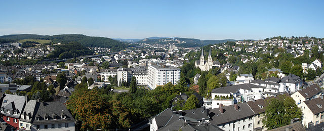
| 15:38, 2 August 2005 |  | 1,900 × 1,159 (529 KB) | Bob. (talk | contribs) | *Description: Aussicht von der Plattform des Oberen Schlosses, Siegen auf das nördliche Stadtgebiet sowie den Stadtteil Weidenau. In der Mitte verläuft die B 62, links die Trassenführung der HTS. Im Hintergrund sind die Gebäude der Universität si |
You cannot overwrite this file.
File usage on Commons
The following 3 pages use this file:
File usage on other wikis
The following other wikis use this file:
- Usage on azb.wikipedia.org
- Usage on da.wikipedia.org
- Usage on de.wikipedia.org
- Usage on en.wikipedia.org
- Usage on hu.wikipedia.org
- Usage on ie.wikipedia.org
- Usage on incubator.wikimedia.org
- Usage on kk.wikipedia.org
- Usage on nn.wikipedia.org
- Usage on no.wikipedia.org
- Usage on ru.wikipedia.org
- Usage on sv.wikipedia.org
- Usage on uk.wikipedia.org