File:Sierra Leone River Estuary ESA353596.jpg

Original file (1,920 × 1,263 pixels, file size: 2.83 MB, MIME type: image/jpeg)
Captions
Captions
Summary edit
| Description |
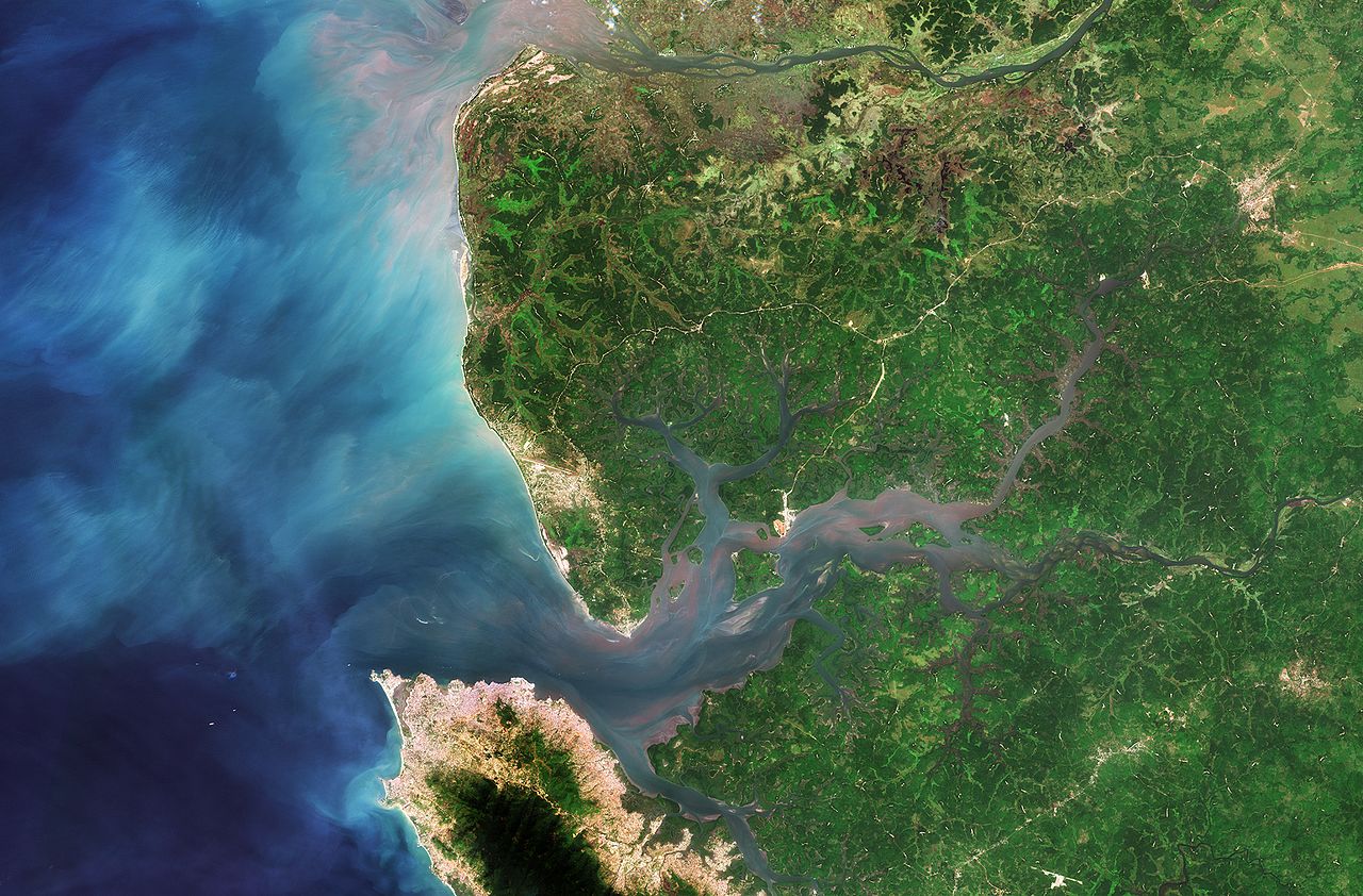
English: Part of Sierra Leone in West Africa is pictured in this image the Sentinel-2A satellite captured on 11 December 2015.
The country’s capital, Freetown, sits on a peninsula at the bottom of the image. Its economy revolves around its natural deep water harbour – one of the world’s largest. North of Freetown and across the river, we can see the runways of the Lungi International Airport. The area in the central-right portion of the image is the Sierra Leone River Estuary. The estuary is dominated by mangroves and lowland coastal plains and is an important breeding habitat for multiple waterbird species. Diverse socio-economic activities are supported by the estuary, such as fishing, tourism and sea transport, which help to alleviate poverty at the community level. But the estuary is being threatened by a growing population. For example, unauthorised housing development has caused the removal of about 20 hectares of mangrove vegetation over the past five years alone. Poor waste disposal, unsustainable fishing and many other factors are also taking their toll on the ecosystem. Some 295 000 hectares of this estuary is protected under the Ramsar Convention – an intergovernmental treaty for the sustainable use of wetlands. There are over 2000 sites worldwide considered to be wetlands of international importance by the Convention. ESA assists the Ramsar Convention through the GlobWetland Africa project and the TIGER initiative ‘Looking After Water in Africa’, which provide satellite data to be used to monitor and sustainably manage these precious resources. World Wetlands Day is observed on 2 February, the anniversary of the signing of the Convention. The theme of this year’s World Wetlands Day is ‘Wetlands for our Future: Sustainable Livelihoods’. This image is also featured on theEarth from Space video programme. |
| Date | |
| Source | http://www.esa.int/spaceinimages/Images/2016/01/Sierra_Leone_River_Estuary |
| Author | European Space Agency |
| Permission (Reusing this file) |
Copernicus Sentinel data (2015)/ESA,CC BY-SA 3.0 IGO |
| Other versions |
|
| Title | Sierra Leone River Estuary |
| Set | Earth observation image of the week |
| System | Copernicus |
| Mission | Sentinel-2 |
| Location | Sierra Leone |
| Activity | Observing the Earth |
| Keywords | Satellite image; River; Rivers; Wetlands |

Licensing edit
- You are free:
- to share – to copy, distribute and transmit the work
- to remix – to adapt the work
- Under the following conditions:
- attribution – You must give appropriate credit, provide a link to the license, and indicate if changes were made. You may do so in any reasonable manner, but not in any way that suggests the licensor endorses you or your use.
- share alike – If you remix, transform, or build upon the material, you must distribute your contributions under the same or compatible license as the original.

|
This image contains data from a satellite in the Copernicus Programme, such as Sentinel-1, Sentinel-2 or Sentinel-3. Attribution is required when using this image.
Attribution: Contains modified Copernicus Sentinel data {{{year}}}
The use of Copernicus Sentinel Data is regulated under EU law (Commission Delegated Regulation (EU) No 1159/2013 and Regulation (EU) No 377/2014). Relevant excerpts:
Free access shall be given to GMES dedicated data [...] made available through GMES dissemination platforms [...].
Access to GMES dedicated data [...] shall be given for the purpose of the following use in so far as it is lawful:
GMES dedicated data [...] may be used worldwide without limitations in time.
GMES dedicated data and GMES service information are provided to users without any express or implied warranty, including as regards quality and suitability for any purpose. |
File history
Click on a date/time to view the file as it appeared at that time.
| Date/Time | Thumbnail | Dimensions | User | Comment | |
|---|---|---|---|---|---|
| current | 22:12, 7 May 2017 | | 1,920 × 1,263 (2.83 MB) | Fæ (talk | contribs) | European Space Agency, Id 353596, http://www.esa.int/spaceinimages/Images/2016/01/Sierra_Leone_River_Estuary, User:Fæ/Project_list/ESA |
You cannot overwrite this file.
File usage on Commons
The following 2 pages use this file:
File usage on other wikis
The following other wikis use this file:
- Usage on lv.wikipedia.org
- Usage on pl.wikipedia.org