File:Skálholt Map.jpg

Original file (830 × 1,023 pixels, file size: 191 KB, MIME type: image/jpeg)
Captions
Captions
Summary edit
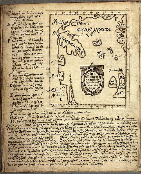
| Description |
English: Map depicting the Atlantic Ocean, from Norse mythology sources. |
| Date | (original) 1669 (this copy) |
| Source | http://strangemaps.wordpress.com/2010/01/17/433-plotting-vineland-the-skalholt-map/ |
| Author | Sigurd Stefánsson (original), Biørn Jonsen (this copy) |
Licensing edit
|
This work is in the public domain in its country of origin and other countries and areas where the copyright term is the author's life plus 70 years or fewer.
| |
| This file has been identified as being free of known restrictions under copyright law, including all related and neighboring rights. | |
| Annotations | This image is annotated: View the annotations at Commons |
File history
Click on a date/time to view the file as it appeared at that time.
| Date/Time | Thumbnail | Dimensions | User | Comment | |
|---|---|---|---|---|---|
| current | 11:24, 17 January 2010 | | 830 × 1,023 (191 KB) | Petter Strandmark (talk | contribs) | {{Information |Description={{en|1=Map depicting the Atlantic Ocean, from Norse mythology sources.}} |Source=http://strangemaps.wordpress.com/2010/01/17/433-plotting-vineland-the-skalholt-map/ |Author=Sigurd Stefánsson (original), Biørn Jonsen (this copy |
You cannot overwrite this file.
File usage on Commons
There are no pages that use this file.
File usage on other wikis
The following other wikis use this file:
- Usage on fr.wikipedia.org