File:Skarżysko-Kamienna location map.png

Size of this preview: 542 × 600 pixels. Other resolutions: 217 × 240 pixels | 434 × 480 pixels | 694 × 768 pixels | 925 × 1,024 pixels | 1,899 × 2,101 pixels.
Original file (1,899 × 2,101 pixels, file size: 2.43 MB, MIME type: image/png)
Captions
Captions
Add a one-line explanation of what this file represents
Summary edit
| Description |
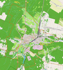
English: OpenStreepMap location map of Skarżysko-Kamienna, Poland:
|
| Date | |
| Source | OpenStreetMap |
| Author | OpenStreetMap contributors |
Licensing edit
| This work contains information from OpenStreetMap, which is made available under the Open Database License (ODbL).
The ODbL does not require any particular license for maps produced from ODbL data. Prior to 1 August 2020, map tiles produced by the OpenStreetMap Foundation were licensed under the CC-BY-SA-2.0 license. Maps produced by other people may be subject to other licences. |
File history
Click on a date/time to view the file as it appeared at that time.
| Date/Time | Thumbnail | Dimensions | User | Comment | |
|---|---|---|---|---|---|
| current | 16:38, 24 March 2019 | | 1,899 × 2,101 (2.43 MB) | Smat (talk | contribs) | correct map |
| 18:00, 11 January 2013 |  | 700 × 818 (297 KB) | Himiltruda (talk | contribs) | User created page with UploadWizard |
You cannot overwrite this file.
File usage on Commons
The following page uses this file:
File usage on other wikis
The following other wikis use this file:
- Usage on pl.wikipedia.org
- Muzeum im. Orła Białego
- Bazylika Matki Bożej Ostrobramskiej w Skarżysku-Kamiennej
- Skarżysko-Kamienna (stacja kolejowa)
- Skarżysko Zachodnie (przystanek kolejowy)
- Pogorzałe (Skarżysko-Kamienna)
- Mesko
- Synagoga w Skarżysku-Kamiennej
- Skarżysko Książęce
- Skarżysko Milica
- Miejska Komunikacja Samochodowa w Skarżysku-Kamiennej
- Bór (Skarżysko-Kamienna)
- Skarżysko Zachodnie
- Cmentarz wojenny Podobwodu Skarżysko-Kamienna AK
- Skarżysko Kościelne (przystanek kolejowy)
- Parafia Matki Bożej Bolesnej w Skarżysku-Kamiennej
- Cmentarz żydowski w Skarżysku-Kamiennej
- Jezioro Rejowskie
- Parafia Świętych Apostołów Piotra i Pawła w Skarżysku-Kamiennej
- Parafia Matki Bożej Częstochowskiej w Skarżysku-Kamiennej
- Parafia Matki Bożej Nieustającej Pomocy w Skarżysku-Kamiennej
- Parafia św. Brata Alberta w Skarżysku-Kamiennej
- Parafia Niepokalanego Poczęcia Najświętszej Maryi Panny w Skarżysku-Kamiennej
- Parafia Matki Bożej Ostrobramskiej w Skarżysku-Kamiennej
- Parafia Najświętszego Serca Jezusa w Skarżysku-Kamiennej
- Parafia św. Józefa Oblubieńca w Skarżysku-Kamiennej
- Kościół Świętego Józefa Oblubieńca w Skarżysku-Kamiennej
- Rejów (Skarżysko-Kamienna)
- Zalew Bernatka
- Tracze
- Milica-Przylesie
- Kościół Najświętszego Serca Jezusa w Skarżysku-Kamiennej
- Milica
- Bzin
- Moduł:Mapa/dane/Skarżysko-Kamienna
- I Liceum Ogólnokształcące im. Juliusza Słowackiego w Skarżysku-Kamiennej
- Bzinek
- Borki (Skarżysko-Kamienna)
- Łyżwy (Skarżysko-Kamienna)
- Usłów
- Kościół Niepokalanego Poczęcia Najświętszej Maryi Panny w Skarżysku-Kamiennej
- Kościół św. Józefa Oblubieńca w Skarżysku-Kamiennej (nowy)
- Kościół Matki Bożej Częstochowskiej w Skarżysku-Kamiennej
- Kościół Świętych Apostołów Piotra i Pawła w Skarżysku-Kamiennej
- Kościół św. Brata Alberta w Skarżysku-Kamiennej
- Kościół Matki Bożej Nieustającej Pomocy w Skarżysku-Kamiennej
- Nowy Młyn (Skarżysko-Kamienna)
- Pastwiska (Skarżysko-Kamienna)
- Osiedle Książęce (Skarżysko-Kamienna)
- Kamienna (Skarżysko-Kamienna)
- Młodzawy (Skarżysko-Kamienna)
View more global usage of this file.