File:Slovakia-map.png
No higher resolution available.
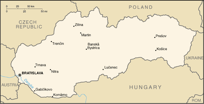
Slovakia-map.png (658 × 337 pixels, file size: 11 KB, MIME type: image/png)
Captions
Captions
Add a one-line explanation of what this file represents

|
File:Slovakia map rivers and cities 2008-11-17.svg is a vector version of this file. It should be used in place of this PNG file when not inferior.
File:Slovakia-map.png → File:Slovakia map rivers and cities 2008-11-17.svg
For more information, see Help:SVG. |
 |
Summary edit
From Cia Factbook
Licensing edit
This image is in the public domain because it contains materials that originally came from the United States Central Intelligence Agency's World Factbook.
|
 |
derivative works edit
Derivative works of this file: Slovacchiait.png
File history
Click on a date/time to view the file as it appeared at that time.
| Date/Time | Thumbnail | Dimensions | User | Comment | |
|---|---|---|---|---|---|
| current | 21:16, 17 September 2005 | | 658 × 337 (11 KB) | Gmelfi (talk | contribs) | [Category:Maps of Slovakia] From Cia Factbook |
You cannot overwrite this file.
File usage on Commons
The following 2 pages use this file:
File usage on other wikis
The following other wikis use this file:
- Usage on dsb.wikipedia.org
- Usage on fa.wikipedia.org
- Usage on gl.wikipedia.org
- Usage on lfn.wikipedia.org
- Usage on nl.wikipedia.org
- Usage on ps.wikipedia.org
- Usage on pt.wikipedia.org
- Usage on sq.wikipedia.org
- Usage on sw.wikipedia.org