File:Slovenia Regions.png

Size of this preview: 800 × 487 pixels. Other resolutions: 320 × 195 pixels | 640 × 390 pixels | 1,025 × 624 pixels.
Original file (1,025 × 624 pixels, file size: 20 KB, MIME type: image/png)
Captions
Captions
Add a one-line explanation of what this file represents
Summary
edit
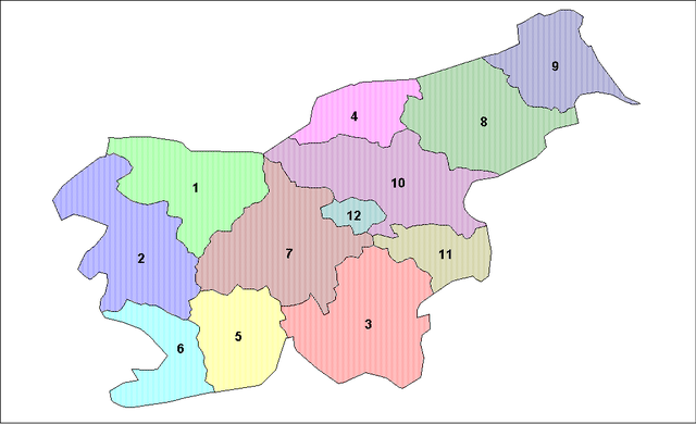
| Description | Map of the regions of Slovenia (statistical purposes only). |
| Date | |
| Source | |
| Author | Created by Rarelibra. Created using MapInfo Professional v7.5 and various mapping resources. THANK YOU to Edolen1 for his updated information! |
Licensing
edit
| This work has been released into the public domain by its author, Rarelibra. This applies worldwide. In some countries this may not be legally possible; if so: |
File history
Click on a date/time to view the file as it appeared at that time.
| Date/Time | Thumbnail | Dimensions | User | Comment | |
|---|---|---|---|---|---|
| current | 06:04, 2 June 2006 | | 1,025 × 624 (20 KB) | Andrejj (talk | contribs) | == Summary == Map of the regions of Slovenia (statistical purposes only). Created by Rarelibra for public domain use. Created using MapInfo Professional v7.5 and various mapping resources. THANK YOU to User:Edolen1 for his updated i |
You cannot overwrite this file.
File usage on Commons
The following page uses this file:
File usage on other wikis
The following other wikis use this file:
- Usage on bg.wikipedia.org
- Usage on en.wikipedia.org
- Usage on eo.wikipedia.org
- Usage on es.wikipedia.org
- Usage on eu.wikipedia.org
- Usage on gl.wikipedia.org
- Usage on hr.wikipedia.org
- Usage on hu.wikipedia.org
- Usage on is.wikipedia.org
- Usage on lt.wikipedia.org
- Usage on pt.wikipedia.org
- Usage on ro.wikipedia.org
- Usage on sh.wikipedia.org
- Usage on sk.wikipedia.org
- Usage on tr.wikipedia.org
- Usage on uk.wikipedia.org