File:Smits reef map.png

Size of this preview: 560 × 599 pixels. Other resolutions: 224 × 240 pixels | 448 × 480 pixels | 717 × 768 pixels | 957 × 1,024 pixels | 1,913 × 2,048 pixels | 7,774 × 8,321 pixels.
Original file (7,774 × 8,321 pixels, file size: 6.41 MB, MIME type: image/png)
Captions
Captions
Add a one-line explanation of what this file represents
Summary edit
| Description |
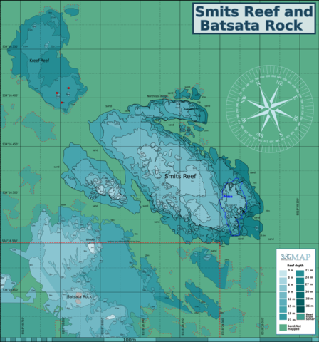
English: Map of the reef at Seekatbank, Smitswinkel Bay. Incomplete contour map at 3m interval isobaths and reef extent, Smitswinkel Bay, Cape Peninsula. |
| Date | |
| Source | P.B.Southwood |
| Author | Peter Southwood |
Licensing edit
Peter Southwood, the copyright holder of this work, hereby publishes it under the following license:
This file is licensed under the Creative Commons Attribution-Share Alike 3.0 Unported license.
Attribution: Peter Southwood
- You are free:
- to share – to copy, distribute and transmit the work
- to remix – to adapt the work
- Under the following conditions:
- attribution – You must give appropriate credit, provide a link to the license, and indicate if changes were made. You may do so in any reasonable manner, but not in any way that suggests the licensor endorses you or your use.
- share alike – If you remix, transform, or build upon the material, you must distribute your contributions under the same or compatible license as the original.
Original upload log edit
| This file was imported from Wikivoyage WTS. |
The original description page was here. All following user names refer to wts.wikivoyage-old.
org:
- 2010-07-04 18:57 (WT-shared) Pbsouthwood[dead link] 1153×1243 (139542 bytes) {{Imagecredit|credit=Peter Southwood|captureDate=2010|location=Smitswinkel Bay, Cape Peninsula|source=P.B.Southwood|caption=|description=Map (Import from wikitravel.org/shared)
- 2010-09-05 14:16 (WT-shared) Pbsouthwood[dead link] 1849×1454 (532287 bytes) (Import from wikitravel.org/shared)
- 2010-09-06 09:21 (WT-shared) Pbsouthwood[dead link] 1849×1454 (521066 bytes) (Import from wikitravel.org/shared)
- 2010-09-06 09:25 (WT-shared) Pbsouthwood[dead link] 3374×1933 (608706 bytes) (Import from wikitravel.org/shared)
- 2010-09-06 09:28 (WT-shared) Pbsouthwood[dead link] 1849×1454 (521066 bytes) (Import from wikitravel.org/shared)
- 2010-09-11 20:06 (WT-shared) Pbsouthwood[dead link] 1849×1454 (550055 bytes) (Import from wikitravel.org/shared)
- 2010-10-21 09:46 (WT-shared) Pbsouthwood[dead link] 1849×1454 (563531 bytes) (Import from wikitravel.org/shared)
- 2010-10-22 18:52 (WT-shared) Pbsouthwood[dead link] 1849×1454 (573270 bytes) (Import from wikitravel.org/shared)
- 2010-11-21 15:38 (WT-shared) Pbsouthwood[dead link] 1849×1789 (722009 bytes) (Import from wikitravel.org/shared)
- 2011-04-26 20:50 (WT-shared) Pbsouthwood[dead link] 3155×2997 (1212331 bytes) 12m contour completed for large section of main reef, a bit more of 9m contour and a 6m pinnacle added, Grid converted to degrees and decima (Import from wikitravel.org/shared)
- 2011-07-05 10:25 (WT-shared) Pbsouthwood[dead link] 3000×2842 (1333688 bytes) Extended area and reefs from SA Council for Geoscience Acoustic Facies Interpretation of the Table Mountain Marine Protected Area, Sheet "Sm (Import from wikitravel.org/shared)
- 2011-12-19 06:12 (WT-shared) Pbsouthwood[dead link] 3000×2842 (1376036 bytes) Added more 18m contour to south west, and small 9m contour and spot depth at overhang pinnacle (Import from wikitravel.org/shared)
- 2012-09-10 10:07 Pbsouthwood[dead link] 3000×2842 (1376722 bytes) rm logo
File history
Click on a date/time to view the file as it appeared at that time.
| Date/Time | Thumbnail | Dimensions | User | Comment | |
|---|---|---|---|---|---|
| current | 13:16, 25 April 2021 | | 7,774 × 8,321 (6.41 MB) | Pbsouthwood (talk | contribs) | Update 9m contour |
| 11:43, 30 March 2021 |  | 7,774 × 8,321 (6.34 MB) | Pbsouthwood (talk | contribs) | another correction | |
| 11:40, 30 March 2021 |  | 14,099 × 21,236 (9.37 MB) | Pbsouthwood (talk | contribs) | correction | |
| 11:36, 30 March 2021 |  | 2,813 × 3,425 (1.88 MB) | Pbsouthwood (talk | contribs) | updates of Batsata reef | |
| 09:52, 3 August 2020 |  | 7,774 × 8,321 (5.84 MB) | Pbsouthwood (talk | contribs) | updated wit more 12 and 15m contours at Batsata Rock | |
| 15:17, 20 July 2020 |  | 7,774 × 8,321 (5.67 MB) | Pbsouthwood (talk | contribs) | Reef edge of Batsata reef added | |
| 17:03, 30 December 2018 |  | 7,774 × 8,321 (5.47 MB) | Pbsouthwood (talk | contribs) | perimeter of southern outlier and some 18m contours | |
| 15:22, 8 April 2018 |  | 7,774 × 8,321 (5.37 MB) | Pbsouthwood (talk | contribs) | updated with north west 24m contour and outliers | |
| 14:14, 26 March 2018 |  | 7,774 × 8,321 (5.28 MB) | Pbsouthwood (talk | contribs) | completed 21m contour at Kreef Reef | |
| 17:08, 25 September 2017 |  | 7,765 × 8,312 (5.23 MB) | Pbsouthwood (talk | contribs) | more 21m contour at Kreef reef |
You cannot overwrite this file.
File usage on Commons
The following 15 pages use this file:
- User:Chumwa/OgreBot/Transport Maps/2020 August 1-10
- User:Chumwa/OgreBot/Transport Maps/2020 July 11-20
- User:Chumwa/OgreBot/Transport Maps/2021 April 21-30
- User:Chumwa/OgreBot/Transport Maps/2021 March 21-31
- User:Chumwa/OgreBot/Travel and communication maps/2016 July 11-20
- User:Chumwa/OgreBot/Travel and communication maps/2017 July 1-10
- User:Chumwa/OgreBot/Travel and communication maps/2017 May 21-31
- User:Chumwa/OgreBot/Travel and communication maps/2017 September 21-30
- User:Chumwa/OgreBot/Travel and communication maps/2018 April 1-10
- User:Chumwa/OgreBot/Travel and communication maps/2018 December 21-31
- User:Chumwa/OgreBot/Travel and communication maps/2018 March 21-31
- User:Chumwa/OgreBot/Travel and communication maps/2020 August 1-10
- User:Chumwa/OgreBot/Travel and communication maps/2020 July 11-20
- User:Chumwa/OgreBot/Travel and communication maps/2021 April 21-30
- User:Chumwa/OgreBot/Travel and communication maps/2021 March 21-31
File usage on other wikis
The following other wikis use this file:
- Usage on en.wikivoyage.org
- Usage on shn.wikivoyage.org
- Usage on www.wikidata.org