File:SnowdonMap.svg

Size of this PNG preview of this SVG file: 545 × 600 pixels. Other resolutions: 218 × 240 pixels | 436 × 480 pixels | 698 × 768 pixels | 931 × 1,024 pixels | 1,862 × 2,048 pixels | 1,000 × 1,100 pixels.
Original file (SVG file, nominally 1,000 × 1,100 pixels, file size: 434 KB)
Captions
Captions
Add a one-line explanation of what this file represents
Summary edit
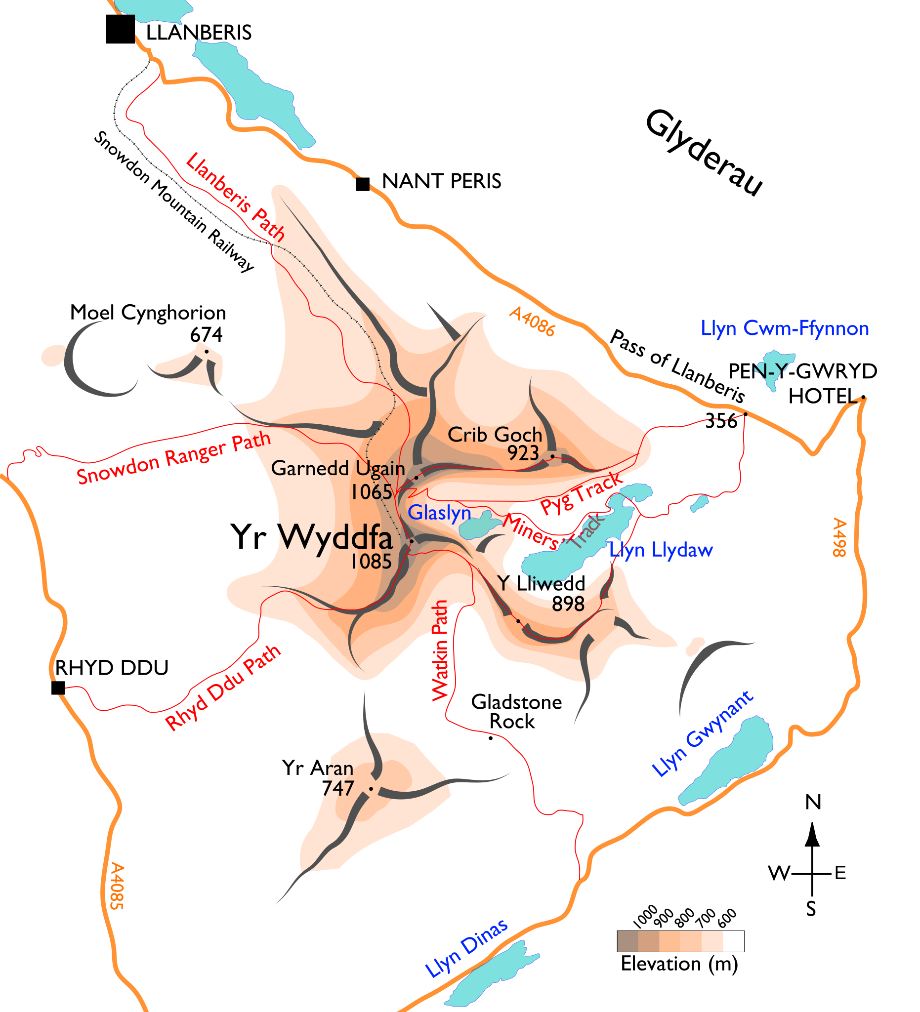
| Description | Map of the Snowdon massif, showing the main paths. |
| Date | |
| Source | Own work. Base mapping is from (public-domain) 1895 edition of M. J. B. Baddeley's Thorough Guide to North Wales. Additional approximate elevation data are cross-referenced from multiple mapping sources, including Ordnance Survey, Google Maps, and personal observations. |
| Author | User:Stemonitis |
| Permission (Reusing this file) |
CC attribution ShareAlike 2.5 |
Licensing edit
This file is licensed under the Creative Commons Attribution-Share Alike 2.5 Generic license.
- You are free:
- to share – to copy, distribute and transmit the work
- to remix – to adapt the work
- Under the following conditions:
- attribution – You must give appropriate credit, provide a link to the license, and indicate if changes were made. You may do so in any reasonable manner, but not in any way that suggests the licensor endorses you or your use.
- share alike – If you remix, transform, or build upon the material, you must distribute your contributions under the same or compatible license as the original.
File history
Click on a date/time to view the file as it appeared at that time.
| Date/Time | Thumbnail | Dimensions | User | Comment | |
|---|---|---|---|---|---|
| current | 10:36, 17 August 2015 | | 1,000 × 1,100 (434 KB) | Dani di Neudo (talk | contribs) | Likewise move the label for the Miners' Track to above Llyn Llydaw to show that it doesn't go over Y Lliwedd. |
| 10:25, 17 August 2015 |  | 1,000 × 1,100 (432 KB) | Dani di Neudo (talk | contribs) | Label Pyg Track only above Bwlch y Moch; lower section from Pen y Pass can be inferred. Lets us show that it doesn't go over Crib Goch (as sadly some might use this for nav in real life!) without need for repeat labels. (No space for alt name "Pig".) | |
| 18:20, 14 August 2015 |  | 1,000 × 1,100 (444 KB) | Dani di Neudo (talk | contribs) | Pyg Track does not come off the Miners' Track but follows a different route from the very start at Pen y Pass - the one that was shown is a right of way that does not exist on the ground. Also a repeat label of the Pyg Track higher up to show that it d... | |
| 18:00, 14 August 2015 |  | 1,000 × 1,100 (437 KB) | Dani di Neudo (talk | contribs) | Top of Watkin Path cuts across south face to Bwlch Main (southwest) ridge. Path between Y Lliwedd and Llyn Llydaw follows the ridge. | |
| 16:20, 26 July 2012 |  | 1,000 × 1,100 (425 KB) | Stemonitis (talk | contribs) | Position of Gladstone Rock corrected | |
| 06:44, 17 July 2012 |  | 1,000 × 1,100 (425 KB) | Stemonitis (talk | contribs) | Alternative spelling of "Pig track" added; minor smoothing tweaks to paths and roads | |
| 19:24, 28 April 2011 |  | 1,000 × 1,100 (419 KB) | Stemonitis (talk | contribs) | Converted remaining text to paths | |
| 18:45, 28 April 2011 |  | 1,000 × 1,100 (394 KB) | Stemonitis (talk | contribs) | Text saved as paths to ensure consistent appearance. | |
| 07:57, 14 April 2011 |  | 1,000 × 1,100 (187 KB) | Stemonitis (talk | contribs) | Text enlarged; elevation shading added; ridge representation altered; other minor changes | |
| 18:32, 9 June 2010 |  | 1,013 × 1,257 (74 KB) | Stemonitis (talk | contribs) | Fix some problems with overlapping text. |
You cannot overwrite this file.
File usage on Commons
The following 2 pages use this file:
File usage on other wikis
The following other wikis use this file:
- Usage on cs.wikipedia.org
- Usage on cy.wikipedia.org
- Usage on de.wikipedia.org
- Usage on en.wikipedia.org
- Usage on es.wikipedia.org
- Usage on fi.wikipedia.org
- Usage on fr.wikipedia.org
- Usage on is.wikipedia.org
- Usage on ja.wikipedia.org
- Usage on jv.wikipedia.org
- Usage on sl.wikipedia.org