File:26W Dec 11 2011 0610Z.jpg
(Redirected from File:South China Sea and Tropical Depression 26w Dec 11 2011 0607Z.jpg)

Size of this preview: 396 × 600 pixels. Other resolutions: 158 × 240 pixels | 317 × 480 pixels | 507 × 768 pixels | 676 × 1,024 pixels | 1,353 × 2,048 pixels | 6,840 × 10,356 pixels.
Original file (6,840 × 10,356 pixels, file size: 54.2 MB, MIME type: image/jpeg)
Captions
Captions
Add a one-line explanation of what this file represents
| Warning | The original file is very high-resolution. It might not load properly or could cause your browser to freeze when opened at full size. |
|---|
| Description |
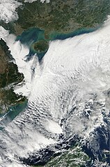
The Moderate Resolution Imaging Spectroradiometer (MODIS) on NASA’s Aqua satellite captured this natural-color image of the South China sea, with Tropical Depression 26w swirling in the southern part of the South China Sea. This photo also features a rare glimpse of Southern China, which is normally covered in cloud cover. Major cities like Hong Kong, can be seen east of the Pearl River Delta near the top of the image, and Hainan Island and Vietnam can is also shown in the photo. Marine Stratocumulus clouds and mostly fog covers much of the northern part of the South China Sea, but barely above land. This is formed when the cool air of the northeast monsoon, spills into the warm South China Sea, gathering moisture evaporated from the sea, condensing into fog or low lying clouds. As the wind continues to move south the wind blows the fog deep into inland Vietnam, before being halted by the mountains of central Indochina, which can be seen in the image. |
|||||
| Date | http://lance-modis.eosdis.nasa.gov/wms/?zoom=5&lat=13.44434&lon=116.5752&layers=000B0FFFFT&datum1=12/11/2011 | |||||
| Source | 12/11/2011 | |||||
| Author | NASA, MODIS Rapid Response System | |||||
| Permission (Reusing this file) |
|

File history
Click on a date/time to view the file as it appeared at that time.
| Date/Time | Thumbnail | Dimensions | User | Comment | |
|---|---|---|---|---|---|
| current | 14:20, 8 November 2015 | | 6,840 × 10,356 (54.2 MB) | Nino Marakot (talk | contribs) | Reverted to version as of 06:36, 4 April 2013 (UTC) |
| 13:17, 22 September 2015 |  | 5,570 × 10,356 (48.56 MB) | Nino Marakot (talk | contribs) | Cropped to a perfect view | |
| 06:36, 4 April 2013 |  | 6,840 × 10,356 (54.2 MB) | Earth100 (talk | contribs) | {{Information |Description=The Moderate Resolution Imaging Spectroradiometer (MODIS) on NASA’s Aqua satellite captured this natural-color image of the South China sea, with Tropical Depression 26w swirling in the southern part of the South China Sea.... |
You cannot overwrite this file.
File usage on Commons
The following 6 pages use this file:
- User talk:Hurricanehink
- User talk:Meow/Archive 1
- User talk:Supportstorm/Archive 1
- Commons:Featured picture candidates/File:South China Sea and Tropical Depression 26w Dec 11 2011 0607Z.jpg
- Commons:Featured picture candidates/Log/April 2013
- File:South China Sea and Tropical Depression 26w Dec 11 2011 0607Z.jpg (file redirect)
File usage on other wikis
The following other wikis use this file:
- Usage on uk.wikipedia.org