File:South Kurdufan in Sudan (Kafia Kingi disputed).svg

Size of this PNG preview of this SVG file: 684 × 600 pixels. Other resolutions: 274 × 240 pixels | 548 × 480 pixels | 876 × 768 pixels | 1,168 × 1,024 pixels | 2,336 × 2,048 pixels | 1,654 × 1,450 pixels.
Original file (SVG file, nominally 1,654 × 1,450 pixels, file size: 353 KB)
Captions
Captions
Add a one-line explanation of what this file represents
Summary edit
.svg&action=edit§ion=1)
| Description |
Deutsch: Lage des Staates XY (siehe Dateiname) im Sudan.
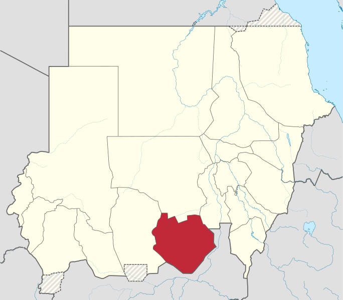
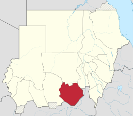
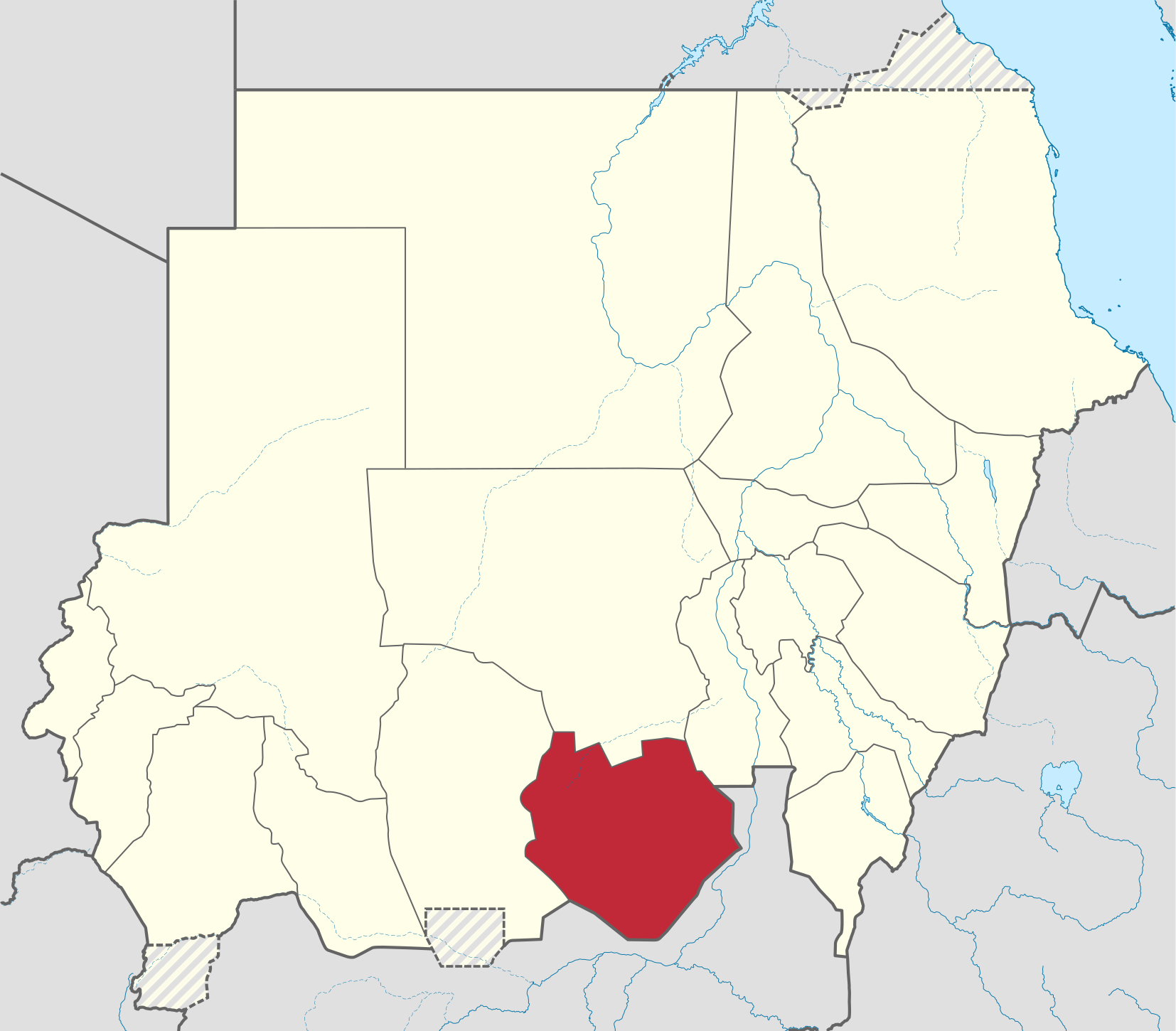
English: Locator map of South Kurdufan state, in the Kurdufan region — in post-2011 Sudan.
|
| Date | |
| Source |
Own work This W3C-unspecified vector image was created with Adobe Illustrator. This SVG file was uploaded with Commonist. This vector image includes elements that have been taken or adapted from this file: |
| Author |
TUBS |
| Other versions |
|
Licensing edit
.svg&action=edit§ion=2)
I, the copyright holder of this work, hereby publish it under the following license:
This file is licensed under the Creative Commons Attribution-Share Alike 3.0 Unported license.
- You are free:
- to share – to copy, distribute and transmit the work
- to remix – to adapt the work
- Under the following conditions:
- attribution – You must give appropriate credit, provide a link to the license, and indicate if changes were made. You may do so in any reasonable manner, but not in any way that suggests the licensor endorses you or your use.
- share alike – If you remix, transform, or build upon the material, you must distribute your contributions under the same or compatible license as the original.

|
I'd greatly appreciate, that you attribute this media file to Wikimedia Commons, if used outside Wikipedia or Commons. For use in publications such as books, newspapers, blogs, websites, please insert here the following line:
|
.svg&action=edit&redlink=1)
File history
Click on a date/time to view the file as it appeared at that time.
| Date/Time | Thumbnail | Dimensions | User | Comment | |
|---|---|---|---|---|---|
| current | 05:33, 28 June 2017 | | 1,654 × 1,450 (353 KB) | SUM1 (talk | contribs) | Reverted to version as of 17:30, 4 October 2014 (UTC) |
| 18:12, 4 October 2014 |  | 1,654 × 1,450 (345 KB) | TUBS (talk | contribs) | Rv. Maybe you are right. But plz correct File:Sudan location map.svg before. The locator map only mirrorrs borders of the location map | |
| 17:30, 4 October 2014 |  | 1,654 × 1,450 (353 KB) | Leftcry (talk | contribs) | Reverted to version as of 23:42, 17 September 2013 | |
| 21:42, 18 September 2013 |  | 1,654 × 1,450 (345 KB) | TUBS (talk | contribs) | Reverted to version as of 21:55, 28 January 2013 plz correct location map before and provide sources | |
| 23:42, 17 September 2013 |  | 1,654 × 1,450 (353 KB) | Spesh531 (talk | contribs) | west kurdufan reformed | |
| 21:55, 28 January 2013 |  | 1,654 × 1,450 (345 KB) | TUBS (talk | contribs) | ||
| 16:36, 23 November 2011 |  | 1,654 × 1,450 (685 KB) | TUBS (talk | contribs) |
You cannot overwrite this file.
File usage on Commons
The following page uses this file:
File usage on other wikis
The following other wikis use this file:
- Usage on ar.wikipedia.org
- Usage on arz.wikipedia.org
- Usage on azb.wikipedia.org
- Usage on bg.wikipedia.org
- Usage on bn.wikipedia.org
- Usage on ca.wikipedia.org
- Usage on cs.wikipedia.org
- Usage on din.wikipedia.org
- Usage on en.wikipedia.org
- Usage on eo.wikipedia.org
- Usage on es.wikipedia.org
- Usage on fa.wikipedia.org
- Usage on fi.wikipedia.org
- Usage on frr.wikipedia.org
- Usage on fr.wikipedia.org
- Usage on ha.wikipedia.org
- Usage on he.wikipedia.org
- Usage on hu.wikipedia.org
- Usage on hy.wikipedia.org
- Usage on ig.wikipedia.org
- Usage on io.wikipedia.org
- Usage on ja.wikipedia.org
- Usage on ka.wikipedia.org
- Usage on ko.wikipedia.org
- Usage on lv.wikipedia.org
- Usage on nl.wikipedia.org
- Usage on pl.wikipedia.org
- Usage on pl.wikivoyage.org
- Usage on pnb.wikipedia.org
- Usage on pt.wikipedia.org
- Usage on ro.wikipedia.org
- Usage on ru.wikipedia.org
- Usage on sh.wikipedia.org
- Usage on sr.wikipedia.org
- Usage on sv.wikipedia.org
- Usage on sw.wikipedia.org
- Usage on ts.wikipedia.org
- Usage on uk.wikipedia.org
- Usage on ur.wikipedia.org
- Usage on vi.wikipedia.org
View more global usage of this file.
.svg)
.svg&oldid=479606426)