File:South West England counties 2009 map.svg

Size of this PNG preview of this SVG file: 764 × 599 pixels. Other resolutions: 306 × 240 pixels | 612 × 480 pixels | 979 × 768 pixels | 1,280 × 1,004 pixels | 2,560 × 2,008 pixels | 1,425 × 1,118 pixels.
Original file (SVG file, nominally 1,425 × 1,118 pixels, file size: 1.83 MB)
Captions
Captions
Add a one-line explanation of what this file represents
Summary edit
| Description |
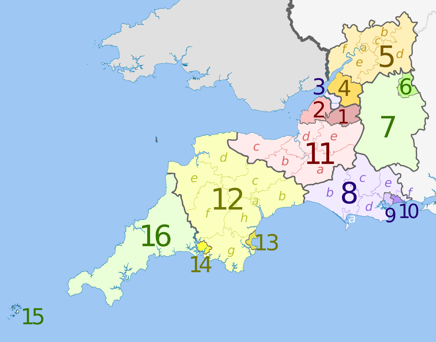
English: Map of the South West England region, showing its counties and administrative districts in 2009. The county colours are the same as those in File:English metropolitan and non-metropolitan counties 2009.svg.
For the districts since 1 April 2023, see File:South West England counties 2023 map.svg. Equirectangular map projection on WGS 84 datum, with N/S stretched 160% Geographic limits:
|
| Date | (UTC) |
| Source |
This file was derived from: |
| Author |
|
| Other versions | File:South West England counties 2023 map.svg – version since 1 April 2023 |

| Map | Ceremonial county | Shire county / unitary | Districts |
|---|---|---|---|
 |
Somerset | 1. Bath and North East Somerset UA | |
| 2. North Somerset UA | |||
| 11. Somerset CC | a) South Somerset, b) Taunton Deane, c) West Somerset, d) Sedgemoor, e) Mendip | ||
| 3. Bristol UA | |||
| Gloucestershire | 4. South Gloucestershire UA | ||
| 5. Gloucestershire CC | a) Gloucester, b) Tewkesbury, c) Cheltenham, d) Cotswold, e) Stroud, f) Forest of Dean | ||
| Wiltshire | 6. Swindon UA | ||
| 7. Wiltshire UA | |||
| Dorset | 8. Dorset CC | a) Weymouth and Portland, b) West Dorset, c) North Dorset, d) Purbeck, e) East Dorset, f) Christchurch | |
| 9. Poole UA | |||
| 10. Bournemouth UA | |||
| Devon | 12. Devon CC | a) Exeter, b) East Devon, c) Mid Devon, d) North Devon, e) Torridge, f) West Devon, g) South Hams, h) Teignbridge | |
| 13. Torbay UA | |||
| 14. Plymouth UA | |||
| Cornwall | 15. Isles of Scilly sui generis UA | ||
| 16. Cornwall UA | |||
UA = unitary authority CC = county council
Licensing edit
This file is licensed under the Creative Commons Attribution-Share Alike 3.0 Unported license.
Attribution: Dr Greg and Nilfanion. Contains Ordnance Survey data © Crown copyright and database right 2011
- You are free:
- to share – to copy, distribute and transmit the work
- to remix – to adapt the work
- Under the following conditions:
- attribution – You must give appropriate credit, provide a link to the license, and indicate if changes were made. You may do so in any reasonable manner, but not in any way that suggests the licensor endorses you or your use.
- share alike – If you remix, transform, or build upon the material, you must distribute your contributions under the same or compatible license as the original.
Original upload log edit
This image is a derivative work of the following images:
- File:South_West_England_districts_2011_map.svg licensed with Cc-by-sa-3.0, GFDL
- 2011-05-01T19:06:01Z Nilfanion 1425x1118 (1924863 Bytes) == Summary == {{Information |Description=Map of the [[w:South West England|South West England]] region showing the administrative districts. Equirectangular map projection on WGS 84 datum, with N/S stretched 160% Geographic
- File:English_ceremonial_counties_2010.svg licensed with Cc-by-sa-3.0, GFDL
- 2010-11-23T16:39:55Z Nilfanion 1108x1345 (308868 Bytes) thicker lines
- 2010-11-23T16:20:19Z Nilfanion 1108x1345 (301520 Bytes) tweaks
- 2010-10-26T20:34:20Z Nilfanion 817x990 (1391832 Bytes) {{Information |Description=Map showing the [[w:ceremonial counties of England]] including the City of London, in 2010. Equirectangular map projection on WGS 84 datum, with N/S stretched 170% Geographic limits: *West: 6.75W
Uploaded with derivativeFX
File history
Click on a date/time to view the file as it appeared at that time.
| Date/Time | Thumbnail | Dimensions | User | Comment | |
|---|---|---|---|---|---|
| current | 20:07, 5 May 2012 | | 1,425 × 1,118 (1.83 MB) | Dr Greg (talk | contribs) | lighten black boundary line |
| 20:47, 2 May 2012 |  | 1,425 × 1,118 (1.83 MB) | Dr Greg (talk | contribs) | == {{int:filedesc}} == {{Information |Description={{en|Map of the South West England region, showing its counties and administrative districts. The county colours are the same as those in [[:File:English metropolitan and non-me... |
You cannot overwrite this file.
File usage on Commons
The following 5 pages use this file:
.svg)
File usage on other wikis
The following other wikis use this file:
- Usage on ar.wikipedia.org
- Usage on fa.wikipedia.org
- Usage on fr.wikipedia.org
- Usage on ja.wikipedia.org
- Usage on mr.wikipedia.org
- Usage on pt.wikipedia.org
- Usage on tr.wikipedia.org
- Usage on vi.wikipedia.org
- Usage on vls.wikipedia.org
- Usage on zh-yue.wikipedia.org