File:South Wilford Endowed CE VA Primary School - geograph.org.uk - 1218001.jpg
South_Wilford_Endowed_CE_VA_Primary_School_-_geograph.org.uk_-_1218001.jpg (640 × 476 pixels, file size: 84 KB, MIME type: image/jpeg)
Captions
Captions
Summary edit
| Description |
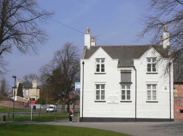
English: South Wilford Endowed CE VA Primary School The 'To Let' sign is slightly misleading; it refers to this building only, not to the school as a whole. However, a building dating from 1736 is hardly suited to modern educational needs.
The tablet above the middle window reads as follows: This School was Erected 1736 pursuant to the will of the Revd MR CARTER late Rector of this Parish who left £200 for that purpose & £50 p annum Salary for the Schoolmaster to be chosen by the Rector for the time being & £5 p annum to buy Books & other Necessarys for the School & £5 p annum to put a Scholar out Apprentice & £5 yearly to ye Poor of this Town & £400 to purchase Land for ye Augmentation of ye aforesaid Charitys . He built ye Parsonage - House Barn Stable & Dove coat. He gave a set of Communion Plate & Beautified the Chancel in his lifetime & left a sum to beautify ye Church answerable to the Chancel & bequeathed many other considerable Charitys. He died ye 23d of December 1732 and lies buried in ye Chancel. W.Tilly Sculpsit Clearly the Rector was a wealthy man for those days. Also of interest in the text of the tablet is the mixed use of p(er) annum and yearly, and also of ye and the. |
| Date | |
| Source | From geograph.org.uk |
| Author | Alan Murray-Rust |
| Attribution (required by the license) | Alan Murray-Rust / South Wilford Endowed CE VA Primary School / |
This is a photo of listed building number 1270640. |
| Camera location | | View this and other nearby images on: OpenStreetMap |
|---|
_heading:22.00&language=en)
| Object location | | View this and other nearby images on: OpenStreetMap |
|---|
_heading:22.00&language=en)
Licensing edit

|
This image was taken from the Geograph project collection. See this photograph's page on the Geograph website for the photographer's contact details. The copyright on this image is owned by Alan Murray-Rust and is licensed for reuse under the Creative Commons Attribution-ShareAlike 2.0 license.
|
- You are free:
- to share – to copy, distribute and transmit the work
- to remix – to adapt the work
- Under the following conditions:
- attribution – You must give appropriate credit, provide a link to the license, and indicate if changes were made. You may do so in any reasonable manner, but not in any way that suggests the licensor endorses you or your use.
- share alike – If you remix, transform, or build upon the material, you must distribute your contributions under the same or compatible license as the original.
File history
Click on a date/time to view the file as it appeared at that time.
| Date/Time | Thumbnail | Dimensions | User | Comment | |
|---|---|---|---|---|---|
| current | 07:41, 26 February 2011 | | 640 × 476 (84 KB) | GeographBot (talk | contribs) | == {{int:filedesc}} == {{Information |description={{en|1=South Wilford Endowed CE VA Primary School The 'To Let' sign is slightly misleading; it refers to this building only, not to the school as a whole. However, a building dating from 1736 is hardly sui |
You cannot overwrite this file.
File usage on Commons
There are no pages that use this file.
File usage on other wikis
The following other wikis use this file:
- Usage on en.wikipedia.org