File:Spiller's Mill after the fire, caution - geograph.org.uk - 1777814.jpg
No higher resolution available.
Spiller's_Mill_after_the_fire,_caution_-_geograph.org.uk_-_1777814.jpg (800 × 577 pixels, file size: 102 KB, MIME type: image/jpeg)
Captions
Captions
Add a one-line explanation of what this file represents
Summary edit
| Description |
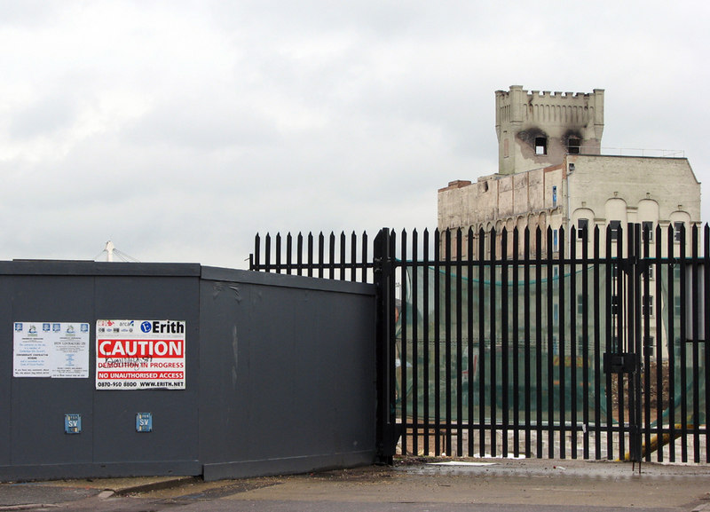
English: Spiller's Mill after the fire: caution The former flour mill was set to become a cultural centre as part of the CB1 development west of Cambridge Station, but was partially destroyed by fire early on 27 March 2010. It may now have to be demolished. Arson has not been ruled out. This picture is taken from the junction of Hills Road and Brooklands Avenue. |
| Date | |
| Source | From geograph.org.uk |
| Author | John Sutton |
| Attribution (required by the license) | John Sutton / Spiller's Mill after the fire: caution / |
| Camera location | | View this and other nearby images on: OpenStreetMap |
|---|
_heading:45.00&language=en)
| Object location | | View this and other nearby images on: OpenStreetMap |
|---|
_heading:45.00&language=en)
Licensing edit

|
This image was taken from the Geograph project collection. See this photograph's page on the Geograph website for the photographer's contact details. The copyright on this image is owned by John Sutton and is licensed for reuse under the Creative Commons Attribution-ShareAlike 2.0 license.
|
This file is licensed under the Creative Commons Attribution-Share Alike 2.0 Generic license.
Attribution: John Sutton
- You are free:
- to share – to copy, distribute and transmit the work
- to remix – to adapt the work
- Under the following conditions:
- attribution – You must give appropriate credit, provide a link to the license, and indicate if changes were made. You may do so in any reasonable manner, but not in any way that suggests the licensor endorses you or your use.
- share alike – If you remix, transform, or build upon the material, you must distribute your contributions under the same or compatible license as the original.
File history
Click on a date/time to view the file as it appeared at that time.
| Date/Time | Thumbnail | Dimensions | User | Comment | |
|---|---|---|---|---|---|
| current | 13:33, 14 March 2011 | | 800 × 577 (102 KB) | GeographBot (talk | contribs) | == {{int:filedesc}} == {{Information |description={{en|1=Spiller's Mill after the fire: caution The former flour mill was set to become a cultural centre as part of the CB1 development west of Cambridge Station, but was partially destroyed by fire early o |
You cannot overwrite this file.
File usage on Commons
There are no pages that use this file.