File:St Botolph's church in West Briggs - C18 memorial - geograph.org.uk - 1741831.jpg
St_Botolph's_church_in_West_Briggs_-_C18_memorial_-_geograph.org.uk_-_1741831.jpg (600 × 543 pixels, file size: 105 KB, MIME type: image/jpeg)
File information
Structured data
Captions
Captions
Add a one-line explanation of what this file represents
Summary edit
| DescriptionSt Botolph's church in West Briggs - C18 memorial - geograph.org.uk - 1741831.jpg |
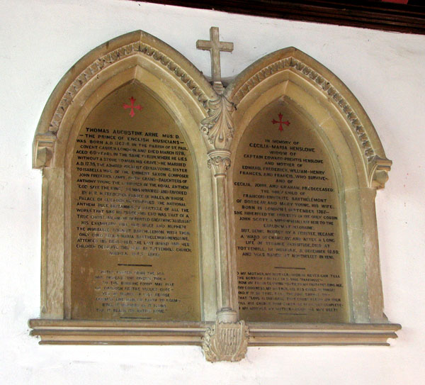
English: St Botolph's church in West Briggs - C18 memorial Memorial to Thomas Arne, MusD.
The church of St Botholph > https://www.geograph.org.uk/photo/1741771 stands by a sharp bend in a narrow lane east of the A134 road. It once used to serve the nearby hamlet of West Briggs > https://www.geograph.org.uk/photo/1741748 of which there remains no trace. After the nearby church in Tottenhill - described by Bloomefeld as a hamlet to West Briggs - fell into ruin, St Bothoph's church was taken over by the village. The tower dates from the 14th century but the building is of Norman origins. It retains the original Norman south and north doorways and the Norman chancel arch > https://www.geograph.org.uk/photo/1741820 - the latter was restored in 1877 by architect Wm Lawrie of Downham Market. Several coloured floor tiles have been reset at the chancel step - these are early medieval and were made in nearby Bawsey. Above the south door there is a stone cross encircled by a carved rope > https://www.geograph.org.uk/photo/1741814. The chancel was restored and the east wall rebuilt in 1864 by architect Ewan Christian. |
| Date | |
| Source | From geograph.org.uk |
| Author | Evelyn Simak |
| Attribution (required by the license) InfoField | Evelyn Simak / St Botolph's church in West Briggs - C18 memorial / |
InfoField | Evelyn Simak / St Botolph's church in West Briggs - C18 memorial |
| Camera location | 52° 40′ 14″ N, 0° 26′ 39″ E | View this and other nearby images on: OpenStreetMap |
|---|
| Object location | 52° 40′ 14″ N, 0° 26′ 39″ E | View this and other nearby images on: OpenStreetMap |
|---|
Licensing edit

|
This image was taken from the Geograph project collection. See this photograph's page on the Geograph website for the photographer's contact details. The copyright on this image is owned by Evelyn Simak and is licensed for reuse under the Creative Commons Attribution-ShareAlike 2.0 license.
|
This file is licensed under the Creative Commons Attribution-Share Alike 2.0 Generic license.
Attribution: Evelyn Simak
- You are free:
- to share – to copy, distribute and transmit the work
- to remix – to adapt the work
- Under the following conditions:
- attribution – You must give appropriate credit, provide a link to the license, and indicate if changes were made. You may do so in any reasonable manner, but not in any way that suggests the licensor endorses you or your use.
- share alike – If you remix, transform, or build upon the material, you must distribute your contributions under the same or compatible license as the original.
File history
Click on a date/time to view the file as it appeared at that time.
| Date/Time | Thumbnail | Dimensions | User | Comment | |
|---|---|---|---|---|---|
| current | 20:12, 5 March 2011 |  | 600 × 543 (105 KB) | GeographBot (talk | contribs) | == {{int:filedesc}} == {{Information |description={{en|1=St Botolph's church in West Briggs - C18 memorial Memorial to Thomas Arne, MusD. The church of St Botholph > http://www.geograph.org.uk/photo/1741771 stands by a sharp bend in a narrow lane east |
You cannot overwrite this file.
File usage on Commons
There are no pages that use this file.
Metadata
This file contains additional information such as Exif metadata which may have been added by the digital camera, scanner, or software program used to create or digitize it. If the file has been modified from its original state, some details such as the timestamp may not fully reflect those of the original file. The timestamp is only as accurate as the clock in the camera, and it may be completely wrong.
| Camera manufacturer | Canon |
|---|---|
| Camera model | Canon PowerShot S3 IS |
| Exposure time | 1/60 sec (0.016666666666667) |
| F-number | f/3.2 |
| Date and time of data generation | 10:58, 7 March 2010 |
| Lens focal length | 10.2 mm |
| Orientation | Normal |
| Horizontal resolution | 180 dpi |
| Vertical resolution | 180 dpi |
| File change date and time | 21:28, 7 March 2010 |
| Y and C positioning | Centered |
| Software used | Adobe Photoshop CS Windows |
| Exif version | 2.2 |
| Date and time of digitizing | 10:58, 7 March 2010 |
| Image compression mode | 3 |
| APEX shutter speed | 5.90625 |
| APEX aperture | 3.34375 |
| APEX exposure bias | 0 |
| Maximum land aperture | 3.34375 APEX (f/3.19) |
| Metering mode | Pattern |
| Flash | Flash fired, auto mode |
| Color space | sRGB |
| Focal plane X resolution | 10,097.777777778 |
| Focal plane Y resolution | 10,082.840236686 |
| Focal plane resolution unit | inches |
| Sensing method | One-chip color area sensor |
| Custom image processing | Normal process |
| Exposure mode | Auto exposure |
| White balance | Auto white balance |
| Digital zoom ratio | 1 |
| Scene capture type | Standard |
