File:St George's Town and St George's Garrison , Bermuda OS Map Lieut AJ Savage 1901.jpg

Size of this preview: 800 × 492 pixels. Other resolutions: 320 × 197 pixels | 640 × 393 pixels | 1,024 × 629 pixels | 1,280 × 787 pixels | 2,823 × 1,735 pixels.
Original file (2,823 × 1,735 pixels, file size: 911 KB, MIME type: image/jpeg)
Captions
Captions
Add a one-line explanation of what this file represents
Summary
edit
| Description |
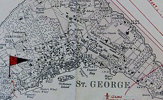
English: Detail from the Ordnance Survey map of the British colony of Bermuda, produced by Lieutenant Arthur Johnson Savage, Royal Engineers, who surveyed Bermuda between 1897 and 1899, showing St. George's Town and St. George's Garrison, Bermuda. The completed map was first printed in 1901.[1][2][3] |
| Date | 1877-1899, printed 1901 |
| Source | Photograph from original copy |
| Author | British Government |
| Camera location | | View this and other nearby images on: OpenStreetMap |
|---|
References
edit
- ↑ Harris, Dr. Edward Cecil (2014-03-22). "Dr Savage’s St George’s walkabout". The Royal Gazette. "Arthur Johnson Savage RE, was responsible for the great Ordnance Survey of the Island that was published in 1901 and is still in print."
- ↑ Jones, Simon (2015-10-23). "Book details history of Savage family". The Royal Gazette.
- ↑ Jones, Simon (2014-04-23). "Family ties to watercolour artist reveal a bygone era: Great-great-grandson of painter returns to island of inspiration". The Bermuda Sun.
This work created by the United Kingdom Government is in the public domain.
This is because it is one of the following:
HMSO has declared that the expiry of Crown Copyrights applies worldwide (ref: HMSO Email Reply)
|
 |
File history
Click on a date/time to view the file as it appeared at that time.
| Date/Time | Thumbnail | Dimensions | User | Comment | |
|---|---|---|---|---|---|
| current | 14:40, 31 December 2019 | | 2,823 × 1,735 (911 KB) | Aodhdubh (talk | contribs) | {{subst:Upload marker added by en.wp UW}} {{Information |Description = {{en|Detail from the Ordnance Survey map of the British colony of Bermuda, produced by Lieutenant Arthur Johnson Savage, Royal Engineers, who surveyed Bermuda between 1897 and 1899, showing St. George's Town and St. George's Garrison, Bermuda. The comple... |
You cannot overwrite this file.
File usage on Commons
There are no pages that use this file.
File usage on other wikis
The following other wikis use this file:
- Usage on de.wikivoyage.org
- Usage on en.wikipedia.org
- Usage on simple.wikipedia.org
- Usage on www.wikidata.org