File:St Mary's Church, Long Wittenham, Oxfordshire - vestry hatchment.jpg
St_Mary's_Church,_Long_Wittenham,_Oxfordshire_-_vestry_hatchment.jpg (640 × 480 pixels, file size: 62 KB, MIME type: image/jpeg)
Captions
Captions
Summary edit
| DescriptionSt Mary's Church, Long Wittenham, Oxfordshire - vestry hatchment.jpg |
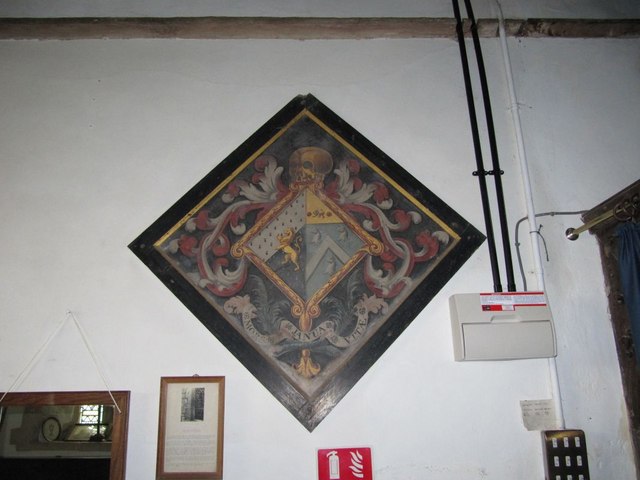
Church of England parish church of St Mary the Virgin, Long Wittenham, Oxfordshire (formerly Berkshire): hatchment in the vestry, shield lozenge shaped, thus for funeral of a female/wife. Trevor impaling Jennens ?. Arms of Trevor / Mostyn / Pennant / Edwards of Lee Castle: Arms of Trevor (Tudor Trevor, a chieftan of the Marches of Wales): Party per bend sinister ermine and ermines, a lion rampant or. From: Longwittenham History Group[1]: In the late seventeenth century Richard Jennens of Long Wittenham owned, amongst other farms, the woody ground, pasture etc. known as Hagbourne Down Farm. A branch of the Jennens family came to Long Wittenham from Harwell in the early 1600s. They were a successful farming family owning or leasing land in many nearby parishes. Down Farm came via legacy and sale within the Jennens family to Elizabeth Jennens, daughter of .... Jennens of Shiplake, (The Historical Register,: Containing an Impartial Relation of All ..., Volume 4[2]) Oxon, and granddaughter of Richard. She had married Tudor Trevor, son of Sir John Trevor (c.1637-1717), Master of the Rolls. When she died in 1784 she left most of her property to John Hayward, her nagman (groom) and he took over her farming activities. |
| Date | |
| Source | From geograph.org.uk |
| Author | Bill Nicholls |
| Attribution (required by the license) InfoField | Bill Nicholls / Heraldic display in the vestry / |
InfoField | Bill Nicholls / Heraldic display in the vestry |
| Camera location | 51° 38′ 34″ N, 1° 12′ 31″ W | View this and other nearby images on: OpenStreetMap |
|---|
| Object location | 51° 38′ 34″ N, 1° 12′ 31″ W | View this and other nearby images on: OpenStreetMap |
|---|
Licensing edit

|
This image was taken from the Geograph project collection. See this photograph's page on the Geograph website for the photographer's contact details. The copyright on this image is owned by Bill Nicholls and is licensed for reuse under the Creative Commons Attribution-ShareAlike 2.0 license.
|
- You are free:
- to share – to copy, distribute and transmit the work
- to remix – to adapt the work
- Under the following conditions:
- attribution – You must give appropriate credit, provide a link to the license, and indicate if changes were made. You may do so in any reasonable manner, but not in any way that suggests the licensor endorses you or your use.
- share alike – If you remix, transform, or build upon the material, you must distribute your contributions under the same or compatible license as the original.
File history
Click on a date/time to view the file as it appeared at that time.
| Date/Time | Thumbnail | Dimensions | User | Comment | |
|---|---|---|---|---|---|
| current | 03:17, 4 March 2011 |  | 640 × 480 (62 KB) | GeographBot (talk | contribs) | == {{int:filedesc}} == {{Information |description={{en|1=Heraldic display in the vestry I peeked a look behind the curtain of what I think is the vestry and noticed an heraldic display (Hatchments) on the wall}} |date=2009-11-08 |source=From [http://www.g |
You cannot overwrite this file.
File usage on Commons
The following page uses this file:
Metadata
This file contains additional information such as Exif metadata which may have been added by the digital camera, scanner, or software program used to create or digitize it. If the file has been modified from its original state, some details such as the timestamp may not fully reflect those of the original file. The timestamp is only as accurate as the clock in the camera, and it may be completely wrong.
| Camera manufacturer | Canon |
|---|---|
| Camera model | Canon PowerShot SX200 IS |
| Exposure time | 1/15 sec (0.066666666666667) |
| F-number | f/3.4 |
| ISO speed rating | 400 |
| Date and time of data generation | 12:52, 8 November 2009 |
| Lens focal length | 5 mm |
| Orientation | Normal |
| Horizontal resolution | 180 dpi |
| Vertical resolution | 180 dpi |
| File change date and time | 12:52, 8 November 2009 |
| Y and C positioning | Co-sited |
| Exif version | 2.21 |
| Date and time of digitizing | 12:52, 8 November 2009 |
| Image compression mode | 3 |
| APEX shutter speed | 3.90625 |
| APEX aperture | 3.53125 |
| APEX exposure bias | 0 |
| Maximum land aperture | 3.53125 APEX (f/3.4) |
| Metering mode | Pattern |
| Flash | Flash fired, auto mode, red-eye reduction mode |
| Color space | sRGB |
| Focal plane X resolution | 16,393.442622951 |
| Focal plane Y resolution | 16,393.442622951 |
| Focal plane resolution unit | inches |
| Sensing method | One-chip color area sensor |
| Custom image processing | Normal process |
| Exposure mode | Auto exposure |
| White balance | Auto white balance |
| Digital zoom ratio | 1 |
| Scene capture type | Standard |
