File:St Mary's church and churchyard - geograph.org.uk - 1408906.jpg

Size of this preview: 450 × 600 pixels. Other resolutions: 180 × 240 pixels | 480 × 640 pixels.
Original file (480 × 640 pixels, file size: 76 KB, MIME type: image/jpeg)
Captions
Captions
Add a one-line explanation of what this file represents
Summary edit
| Description |
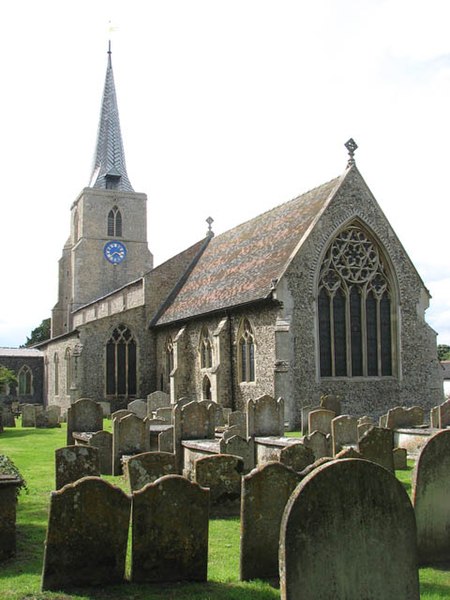
English: St Mary's church and churchyard. St Mary's church > 1408886 - 1408907 as we see it today was mainly built during the 14th century. It is a large church with a square tower that is topped by a lead-covered spire. St Mary's was extensively restored by the then Rector, the Revd J.G. Fardell, in the late 19th century and the furnishings and stained glass windows as well as the ornate font cover date from this time. The nave roof > 1408947 has massive barn-like timbers, tie-beams and kingposts which all appear to be original as is the C14 octagonal font > 1408954. Another survival is the so-called Bardolph Effigy > 1408950 - a knight in armour who rests in a recess built into the north nave wall. Unusually, the statue is of carved oak, painted black presumably in the 19th century in order to resemble stone. According to tradition it depicts Sir Hugh Bardolph who was Lord of Greys Manor in the 12th century. The east window contains glass made by J.R. Clayton in 1857 > 1408914 while he was working with Powell & Sons of London. The north aisle east window > 1408916 is by the same stained glass artist and was made to designs by Henry Holiday. The glass on the south wall > 1408935 believed to be the rarest of the church, is thought to date from the 16th century, a time from which very little remains. 17th century Flemish glass > 1408932 can be found in one of the nave north windows and one of the north chancel windows were made by the well-known London glass maker C.E. Kempe > 1408930. |
| Date | |
| Source | From geograph.org.uk |
| Author | Evelyn Simak |
| Attribution (required by the license) | Evelyn Simak / St Mary's church and churchyard / |
_-_geograph.org.uk_-_1408914.jpg)
| Camera location | | View this and other nearby images on: OpenStreetMap |
|---|
_heading:315.00&language=en)
| Object location | | View this and other nearby images on: OpenStreetMap |
|---|
_heading:315.00&language=en)
Licensing edit

|
This image was taken from the Geograph project collection. See this photograph's page on the Geograph website for the photographer's contact details. The copyright on this image is owned by Evelyn Simak and is licensed for reuse under the Creative Commons Attribution-ShareAlike 2.0 license.
|
This file is licensed under the Creative Commons Attribution-Share Alike 2.0 Generic license.
Attribution: Evelyn Simak
- You are free:
- to share – to copy, distribute and transmit the work
- to remix – to adapt the work
- Under the following conditions:
- attribution – You must give appropriate credit, provide a link to the license, and indicate if changes were made. You may do so in any reasonable manner, but not in any way that suggests the licensor endorses you or your use.
- share alike – If you remix, transform, or build upon the material, you must distribute your contributions under the same or compatible license as the original.
File history
Click on a date/time to view the file as it appeared at that time.
| Date/Time | Thumbnail | Dimensions | User | Comment | |
|---|---|---|---|---|---|
| current | 13:33, 1 March 2011 | | 480 × 640 (76 KB) | GeographBot (talk | contribs) | == {{int:filedesc}} == {{Information |description={{en|1=St Mary's church and churchyard St Mary's church > http://www.geograph.org.uk/photo/1408886 - http://www.geograph.org.uk/photo/1408907 as we see it today was mainly built during the 14th century. I |
You cannot overwrite this file.
File usage on Commons
There are no pages that use this file.