File:St Nicholas Church, Warwick - geograph.org.uk - 1196393.jpg
No higher resolution available.
St_Nicholas_Church,_Warwick_-_geograph.org.uk_-_1196393.jpg (640 × 480 pixels, file size: 98 KB, MIME type: image/jpeg)
Captions
Captions
Add a one-line explanation of what this file represents
Summary edit
| Description |
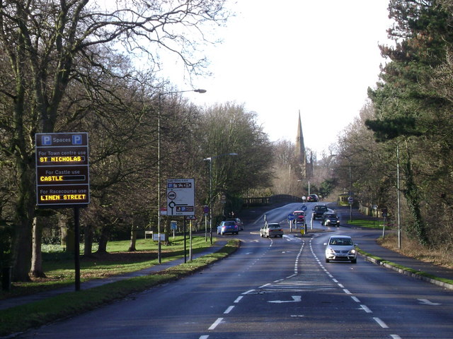
English: St Nicholas Church, Warwick Looking NW from the Banbury Road A425.
In remodelling the Castle Park (e.g.SP2863) in the 18th century, the Earl of Warwick rerouted the approach from Banbury to create a vista whose focal point was the spire of the church. And built Castle Bridge, right of centre, to replace the mediaeval bridge, which he partly demolished to create a picturesque ruin.https://www.geograph.org.uk/photo/421846 https://www.geograph.org.uk/photo/259047 |
| Date | |
| Source | From geograph.org.uk |
| Author | Robin Stott |
| Attribution (required by the license) | Robin Stott / St Nicholas Church, Warwick / |
| Camera location | | View this and other nearby images on: OpenStreetMap |
|---|
_heading:337.00&language=en)
| Object location | | View this and other nearby images on: OpenStreetMap |
|---|
_heading:337.00&language=en)
Licensing edit

|
This image was taken from the Geograph project collection. See this photograph's page on the Geograph website for the photographer's contact details. The copyright on this image is owned by Robin Stott and is licensed for reuse under the Creative Commons Attribution-ShareAlike 2.0 license.
|
This file is licensed under the Creative Commons Attribution-Share Alike 2.0 Generic license.
Attribution: Robin Stott
- You are free:
- to share – to copy, distribute and transmit the work
- to remix – to adapt the work
- Under the following conditions:
- attribution – You must give appropriate credit, provide a link to the license, and indicate if changes were made. You may do so in any reasonable manner, but not in any way that suggests the licensor endorses you or your use.
- share alike – If you remix, transform, or build upon the material, you must distribute your contributions under the same or compatible license as the original.
File history
Click on a date/time to view the file as it appeared at that time.
| Date/Time | Thumbnail | Dimensions | User | Comment | |
|---|---|---|---|---|---|
| current | 01:15, 26 February 2011 | | 640 × 480 (98 KB) | GeographBot (talk | contribs) | == {{int:filedesc}} == {{Information |description={{en|1=St Nicholas Church, Warwick Looking NW from the Banbury Road A425. In remodelling the Castle Park (e.g.SP2863) in the 18th century, the Earl of Warwick rerouted the approach from Banbury to cre |
You cannot overwrite this file.
File usage on Commons
There are no pages that use this file.