File:Stafford Common - geograph.org.uk - 967610.jpg
Stafford_Common_-_geograph.org.uk_-_967610.jpg (640 × 457 pixels, file size: 121 KB, MIME type: image/jpeg)
Captions
Captions
Summary edit
| Description |
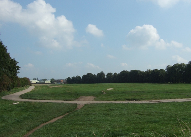
English: Stafford Common. Looking across the Common from the Stone Road side.
The Commons Registration Act 1965 defines common land as land subject to rights of common (as defined in the Act) whether those rights are exercisable at all times or only during limited periods, and waste land of a manor not subject to rights of common. Common land generally has open access rights for the public. Stafford Common extends to 62 ha.(approx 150ac.) and is regularly used for horse shows and car boot sales, hosts cross country running races and is well walked by local residents. It is also used for grazing cattle and horses. The trees to the right, along the southern edge of the Common, follow the line of the old Stafford to Uttoxeter branch railway. There was a small station, called Stafford Common, near the white buildings on the horizon where the track also sent out a spur to serve the nearby saltworks. |
| Date | |
| Source | From geograph.org.uk |
| Author | Simon Huguet |
| Attribution (required by the license) | Simon Huguet / Stafford Common / |
| Camera location | | View this and other nearby images on: OpenStreetMap |
|---|
_heading:90.00&language=en)
| Object location | | View this and other nearby images on: OpenStreetMap |
|---|
_heading:90.00&language=en)
Licensing edit

|
This image was taken from the Geograph project collection. See this photograph's page on the Geograph website for the photographer's contact details. The copyright on this image is owned by Simon Huguet and is licensed for reuse under the Creative Commons Attribution-ShareAlike 2.0 license.
|
- You are free:
- to share – to copy, distribute and transmit the work
- to remix – to adapt the work
- Under the following conditions:
- attribution – You must give appropriate credit, provide a link to the license, and indicate if changes were made. You may do so in any reasonable manner, but not in any way that suggests the licensor endorses you or your use.
- share alike – If you remix, transform, or build upon the material, you must distribute your contributions under the same or compatible license as the original.
File history
Click on a date/time to view the file as it appeared at that time.
| Date/Time | Thumbnail | Dimensions | User | Comment | |
|---|---|---|---|---|---|
| current | 18:08, 22 February 2011 | | 640 × 457 (121 KB) | GeographBot (talk | contribs) | == {{int:filedesc}} == {{Information |description={{en|1=Stafford Common Looking across the Common from the Stone Road side. The Commons Registration Act 1965 defines common land as land subject to rights of common (as defined in the Act) whether th |
You cannot overwrite this file.
File usage on Commons
There are no pages that use this file.