File:Stazione di Carrara Avenza - Piano schematico.png
Size of this preview: 800 × 174 pixels. Other resolutions: 320 × 69 pixels | 640 × 139 pixels | 1,024 × 222 pixels | 1,280 × 278 pixels | 4,981 × 1,081 pixels.
Original file (4,981 × 1,081 pixels, file size: 137 KB, MIME type: image/png)
Captions
Captions
Add a one-line explanation of what this file represents
Summary edit
| Description |
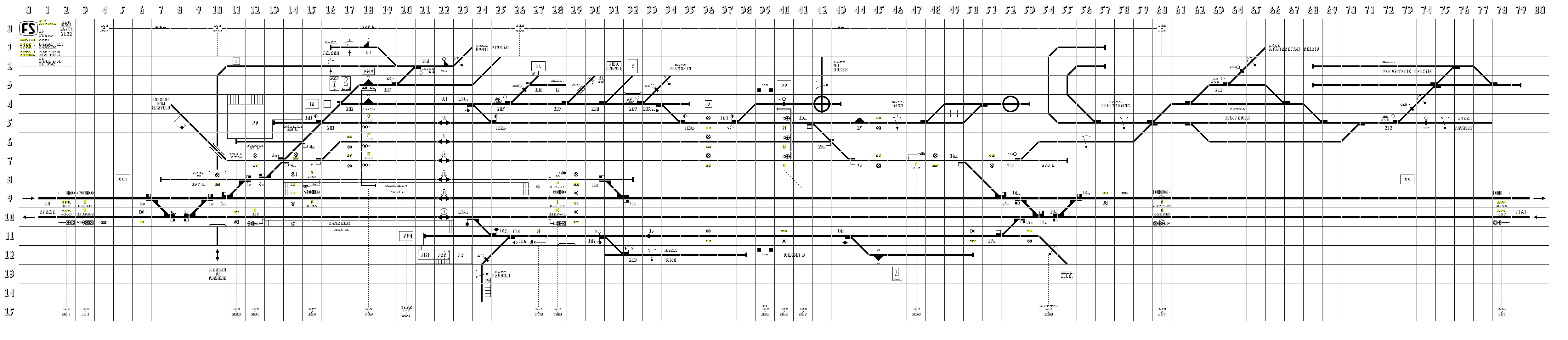
Italiano: Piano schematico approssimativo della stazione di Carrara-Avenza, avente come riferimento il piano schematico originale aggiornato al 1989 delle FS, l'istruzione per l'apparato ACEI di stazione e il quadro luminoso del banco stesso. |
| Date |
|
| Source |
Own work
|
| Author | Claudio Dario |
| Permission (Reusing this file) |
I, the copyright holder of this work, hereby publish it under the following license: This file is licensed under the Creative Commons Attribution-Share Alike 4.0 International license.
|
| Other versions |
|
| Camera location | | View this and other nearby images on: OpenStreetMap |
|---|
File history
Click on a date/time to view the file as it appeared at that time.
| Date/Time | Thumbnail | Dimensions | User | Comment | |
|---|---|---|---|---|---|
| current | 20:50, 26 May 2022 | 4,981 × 1,081 (137 KB) | Claudio Dario (talk | contribs) | Data errata (mfw) | |
| 20:46, 26 May 2022 | 4,981 × 1,081 (137 KB) | Claudio Dario (talk | contribs) | Rev. 2.2.1 - Fix minori | ||
| 15:55, 15 February 2022 | 4,981 × 1,081 (137 KB) | Claudio Dario (talk | contribs) | V. 2.2: aggiustamenti e fix vari, -incongruenza PK (Carrione), logo FS a televisore | ||
| 00:25, 29 January 2022 | 4,981 × 1,081 (134 KB) | Claudio Dario (talk | contribs) | +Fascio campagna e annessi raccordi, numerazione seg. bassi, info e fix vari, +seg. avviso, migliorie grafiche | ||
| 21:08, 11 November 2021 | 3,841 × 1,080 (101 KB) | Claudio Dario (talk | contribs) | Rev. 2A | ||
| 12:35, 26 September 2021 | 3,841 × 1,080 (99 KB) | Claudio Dario (talk | contribs) | Rev. 2 | ||
| 20:16, 17 August 2014 | 3,111 × 825 (112 KB) | Claudio Dario (talk | contribs) | Aggiornamenti vari e perfezionamenti. | ||
| 15:58, 8 May 2014 | 3,111 × 825 (114 KB) | Claudio Dario (talk | contribs) | Rifiniture varie. La prossima versione è la 5.0 . | ||
| 17:36, 21 March 2014 | 3,111 × 825 (112 KB) | Claudio Dario (talk | contribs) | Aggiornato. | ||
| 15:16, 4 March 2014 | 3,111 × 825 (112 KB) | Claudio Dario (talk | contribs) | Ribaltato, rifatto completamente con segn. lumin. alti e bassi, circuiti di binario e, ovviamente, con grafica conforme alla norma italiana CEI 3-8, 1997-05, edizione seconda, fascicolo 3030 R. Sigle e segni grafici per i piani schematici degli impiant... |
You cannot overwrite this file.
File usage on Commons
The following 3 pages use this file:
File usage on other wikis
The following other wikis use this file:
- Usage on it.wikipedia.org