File:Steiermark Seutter 1728 Radkersburg.jpg
Size of this preview: 726 × 600 pixels. Other resolutions: 291 × 240 pixels | 581 × 480 pixels | 930 × 768 pixels | 1,092 × 902 pixels.
Original file (1,092 × 902 pixels, file size: 1.23 MB, MIME type: image/jpeg)
Captions
Captions
Add a one-line explanation of what this file represents
| Description |
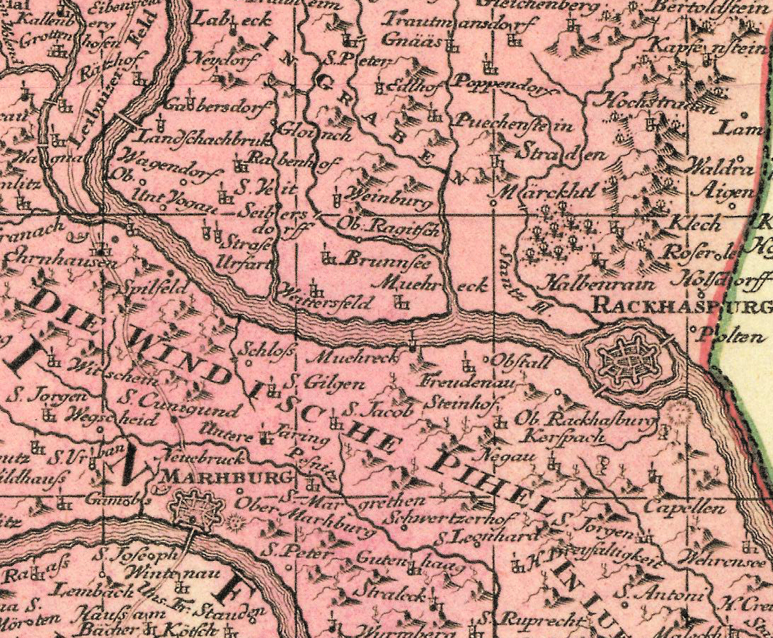
historische Landkarte: Deutsch: Teil von Bad Radkersburg aus File:Steiermark Seutter 1728.jpg ausgeschnitten
Matthäus Seutter, Landkarte des Herzogtums Steiermark, Augsburg-Wien 1728. Gliederung in Obersteiermark, Untersteiermark (ab südlich Frohnleiten, mit Voitsberg und Hartberg) und Grafschaft Cilli. |
|||||||||||||||||||||||
| Date | ||||||||||||||||||||||||
| Source | steiermärkisches Landesarchiv | |||||||||||||||||||||||
| Author |
|
|||||||||||||||||||||||
| Permission (Reusing this file) |
freies Werk aus dem 18. Jahrhundert nach Ablauf der Schutzfristen | |||||||||||||||||||||||

|
This work is in the public domain in its country of origin and other countries and areas where the copyright term is the author's life plus 100 years or fewer. | |
| This file has been identified as being free of known restrictions under copyright law, including all related and neighboring rights. | |
File history
Click on a date/time to view the file as it appeared at that time.
| Date/Time | Thumbnail | Dimensions | User | Comment | |
|---|---|---|---|---|---|
| current | 19:35, 2 March 2014 | | 1,092 × 902 (1.23 MB) | Karl Gruber (talk | contribs) | {{Information |Description=historische Landkarte: {{de|Teil von Bad Radkersburg aus File:Steiermark Seutter 1728.jpg ausgeschnitten}} Matthäus Seutter, Landkarte des Herzogtums Steiermark, Augsburg-Wien 1728. Gliederung in Obersteiermark, Unterst... |
You cannot overwrite this file.
File usage on Commons
There are no pages that use this file.
File usage on other wikis
The following other wikis use this file:
- Usage on de.wikipedia.org