File:Straßenbahn Spandau Netzplan.png

Size of this preview: 599 × 599 pixels. Other resolutions: 240 × 240 pixels | 480 × 480 pixels | 768 × 768 pixels | 1,023 × 1,024 pixels | 2,047 × 2,048 pixels | 7,479 × 7,483 pixels.
Original file (7,479 × 7,483 pixels, file size: 6.52 MB, MIME type: image/png)
Captions
Captions
Add a one-line explanation of what this file represents
Summary edit
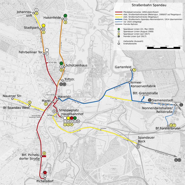
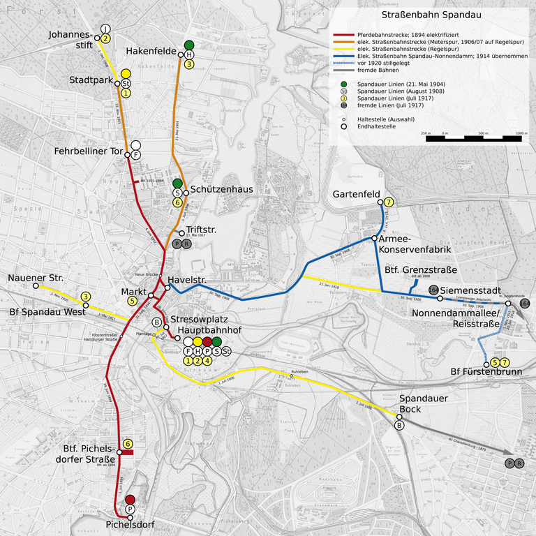
| Description | Streckenkarte der Spandauer Straßenbahn 1892–1920 |
| Source | Eigenes Werk, basierend auf File:Straube Plan der Stadt Spandau 1912.jpg. |
| Author | Christian Liebscher |
Licensing edit
I, the copyright holder of this work, hereby publish it under the following license:
This file is licensed under the Creative Commons Attribution-Share Alike 4.0 International license.
- You are free:
- to share – to copy, distribute and transmit the work
- to remix – to adapt the work
- Under the following conditions:
- attribution – You must give appropriate credit, provide a link to the license, and indicate if changes were made. You may do so in any reasonable manner, but not in any way that suggests the licensor endorses you or your use.
- share alike – If you remix, transform, or build upon the material, you must distribute your contributions under the same or compatible license as the original.
File history
Click on a date/time to view the file as it appeared at that time.
| Date/Time | Thumbnail | Dimensions | User | Comment | |
|---|---|---|---|---|---|
| current | 16:02, 1 April 2023 | | 7,479 × 7,483 (6.52 MB) | Platte (talk | contribs) | Betriebshöfe deutlicher gekennzeichnet |
| 02:27, 31 December 2021 |  | 3,740 × 3,742 (4.42 MB) | Platte (talk | contribs) | freie Schriftart | |
| 21:09, 29 December 2021 |  | 3,740 × 3,742 (4.4 MB) | Platte (talk | contribs) | Maßstableiste korr. | |
| 19:00, 28 December 2021 |  | 3,740 × 3,742 (4.4 MB) | Platte (talk | contribs) | Änderungswünsche gem. WP:KWÜ | |
| 07:39, 26 December 2021 |  | 3,740 × 3,742 (4.27 MB) | Platte (talk | contribs) | {{Information |Description=Streckenkarte der Spandauer Straßenbahn 1892–1920 |Source=Eigenes Werk, basierend auf File:File:Straube Plan der Stadt Spandau 1912.jpg. |Date= |Author= Platte |Permission= |other_versions= }} Category:Tram maps of Berlin Category:Maps of Spandau (district of Berlin) Category:Images by User:Platte |
You cannot overwrite this file.
File usage on Commons
The following 6 pages use this file:
- User:Chumwa/OgreBot/Public transport information/2021 December 21-31
- User:Chumwa/OgreBot/Public transport information/2023 April 1-10
- User:Chumwa/OgreBot/Transport Maps/2021 December 21-31
- User:Chumwa/OgreBot/Transport Maps/2023 April 1-10
- User:Jcornelius/Berlin rail transport/2023 April 1-10
- User:Platte/Rail transport Berlin/2023 April
File usage on other wikis
The following other wikis use this file: