File:Straßenbrunnen123 Wilhelmstadt Seekt- Seeburger Straße (5).jpg

Size of this preview: 412 × 600 pixels. Other resolutions: 165 × 240 pixels | 330 × 480 pixels | 527 × 768 pixels | 703 × 1,024 pixels | 1,872 × 2,725 pixels.
Original file (1,872 × 2,725 pixels, file size: 1.26 MB, MIME type: image/jpeg)
Captions
Captions
Add a one-line explanation of what this file represents
Summary
edit.jpg&action=edit§ion=1)
| Description |
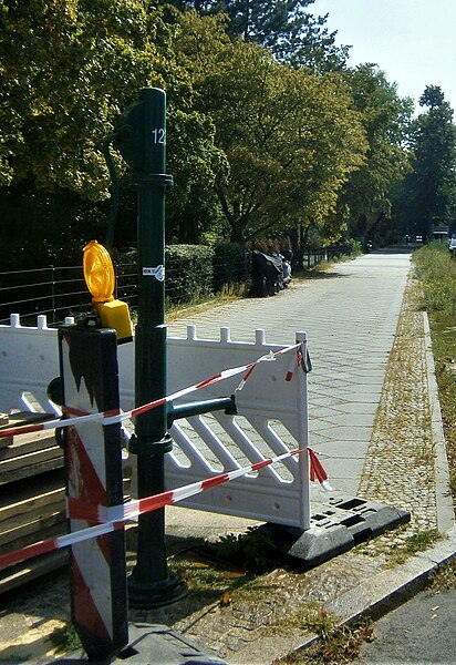
Deutsch: Der FSH-Brunnen steht bereits 2008 an der östlichen Straßenseite der Mündung der Seecktstraße auf die Seeburger Straße. Die Grundstücke Seecktstraße 1 und 3 sind unbebaut. Es folgen Wohnzeilen, die das Grundstücksdreieck seit Ende der 1950er Jahren füllen. Gegenüber vom Brunnen steht die Schule am Gartenfeld.(Seecktstraße 2, Freie Georgenschule[1]) Der Brunnenstandort[2] Der Brunnenststandort befindet sich neben der Stirnseite des südöstlichen sechsgeschossigen Eckhauses der Seeburger Straße, an deren Nordseite sich ein Discountermarkt (Seeburger straße 18) befindet. Der Brunnenfuß und daneben der Straßeneinlass befinden sich im gepflasterten Randstreifen des Gehweg, der zur Seecktstraße abknickt. Verschraubt ist der Ständer auf dem Sockelrohr mit einem Zwischenflansch. Der Wasseraustritt ist am Ansatz der langen Hülse verschraubt. |
| Date | |
| Source | Own work |
| Author | Boonekamp (Günter Haase) |
| Camera location | | View this and other nearby images on: OpenStreetMap |
|---|
.jpg¶ms=052.527758_N_0013.188677_E_globe:Earth_type:camera__&language=en)
Licensing
edit.jpg&action=edit§ion=2)
I, the copyright holder of this work, hereby publish it under the following license:
This file is licensed under the Creative Commons Attribution-Share Alike 4.0 International license.
- You are free:
- to share – to copy, distribute and transmit the work
- to remix – to adapt the work
- Under the following conditions:
- attribution – You must give appropriate credit, provide a link to the license, and indicate if changes were made. You may do so in any reasonable manner, but not in any way that suggests the licensor endorses you or your use.
- share alike – If you remix, transform, or build upon the material, you must distribute your contributions under the same or compatible license as the original.
File history
Click on a date/time to view the file as it appeared at that time.
| Date/Time | Thumbnail | Dimensions | User | Comment | |
|---|---|---|---|---|---|
| current | 10:30, 29 August 2019 | | 1,872 × 2,725 (1.26 MB) | Boonekamp (talk | contribs) | User created page with UploadWizard |
You cannot overwrite this file.
File usage on Commons
The following page uses this file:
File usage on other wikis
The following other wikis use this file:
- Usage on de.wikipedia.org
.jpg&oldid=503927549)