File:Strait tiran 83-ar.jpg

Size of this preview: 472 × 599 pixels. Other resolutions: 189 × 240 pixels | 378 × 480 pixels | 996 × 1,264 pixels.
Original file (996 × 1,264 pixels, file size: 370 KB, MIME type: image/jpeg)
Captions
Captions
Add a one-line explanation of what this file represents
Summary edit
| Description |
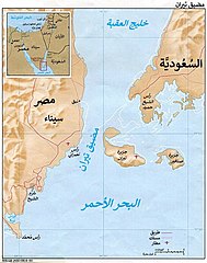
العربية: مضيق تيران بين خليج العقبة والبحر الأحمر. |
| Date | |
| Source |
This file was derived from: Strait tiran 83.jpg |
| Author |
|
| Other versions | English |
| This is a retouched picture, which means that it has been digitally altered from its original version. Modifications: Translated to Arabic - عُرِبَت. The original can be viewed here: Strait tiran 83.jpg:
|
Licensing edit
| This image is a work of a Central Intelligence Agency employee, taken or made as part of that person's official duties. As a Work of the United States Government, this image or media is in the public domain in the United States.
|

|
File history
Click on a date/time to view the file as it appeared at that time.
| Date/Time | Thumbnail | Dimensions | User | Comment | |
|---|---|---|---|---|---|
| current | 22:09, 6 November 2017 | | 996 × 1,264 (370 KB) | باسم (talk | contribs) | User created page with UploadWizard |
You cannot overwrite this file.
File usage on Commons
The following page uses this file:
File usage on other wikis
The following other wikis use this file:
- Usage on ar.wikipedia.org
- Usage on arz.wikipedia.org