File:Subcarpathia Carpatho-Ukraine uk.svg

Size of this PNG preview of this SVG file: 664 × 501 pixels. Other resolutions: 318 × 240 pixels | 636 × 480 pixels | 1,018 × 768 pixels | 1,280 × 966 pixels | 2,560 × 1,932 pixels.
Original file (SVG file, nominally 664 × 501 pixels, file size: 69 KB)
Captions
Captions
Add a one-line explanation of what this file represents
Summary edit
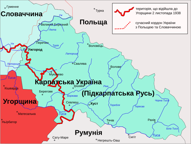
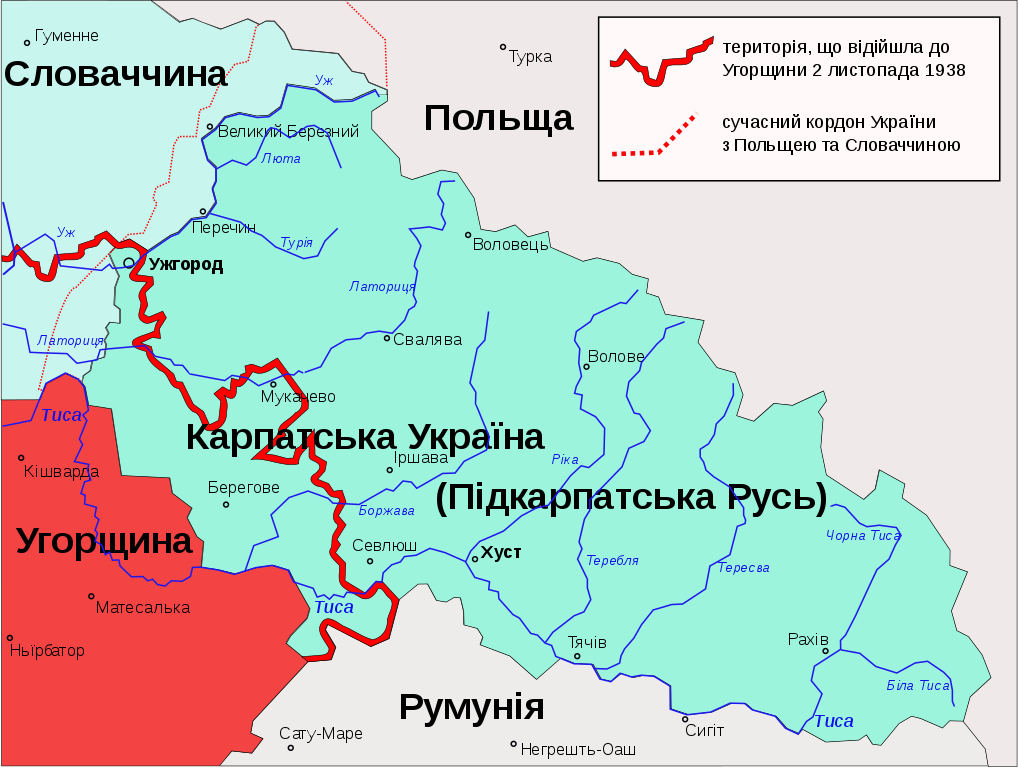
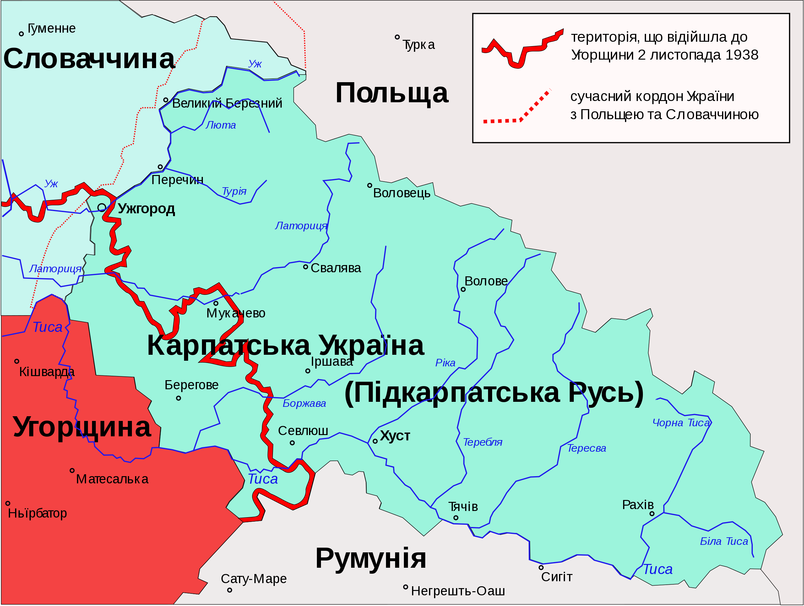
| Description | Карта Карпатської України (1939 рік) |
| Date | (UTC) |
| Source |
This file was derived from: Subcarpathia Carpatho-Ukraine.svg: |
| Author |
|
| Other versions |
|


| This is a retouched picture, which means that it has been digitally altered from its original version. Modifications: translated into Ukrainian. The original can be viewed here: Subcarpathia Carpatho-Ukraine.svg:
|
Licensing edit
This file is licensed under the Creative Commons Attribution-Share Alike 3.0 Unported license.
- You are free:
- to share – to copy, distribute and transmit the work
- to remix – to adapt the work
- Under the following conditions:
- attribution – You must give appropriate credit, provide a link to the license, and indicate if changes were made. You may do so in any reasonable manner, but not in any way that suggests the licensor endorses you or your use.
- share alike – If you remix, transform, or build upon the material, you must distribute your contributions under the same or compatible license as the original.
Original upload log edit
This image is a derivative work of the following images:
- File:Subcarpathia_Carpatho-Ukraine.svg licensed with PD-self
- 2009-11-02T09:24:17Z Malarz pl 688x525 (83228 Bytes) display fix
- 2006-03-22T00:24:41Z PM 688x525 (91589 Bytes)
- 2006-03-22T00:16:37Z PM 688x525 (91591 Bytes) Autonomous Subcarpathian Ruthenia and independent Carpatho-Ukraine 1938-1939. Own work based on different printed and digital maps. [[Category:Maps of Ukraine]]
Uploaded with derivativeFX
File history
Click on a date/time to view the file as it appeared at that time.
| Date/Time | Thumbnail | Dimensions | User | Comment | |
|---|---|---|---|---|---|
| current | 22:15, 8 October 2018 | | 664 × 501 (69 KB) | WithUinH (talk | contribs) | Reverted to version as of 21:27, 8 October 2018 (UTC) |
| 21:34, 8 October 2018 |  | 688 × 525 (82 KB) | WithUinH (talk | contribs) | Reverted to version as of 00:11, 15 March 2013 (UTC) | |
| 21:27, 8 October 2018 |  | 664 × 501 (69 KB) | WithUinH (talk | contribs) | оформлення | |
| 21:19, 8 October 2018 |  | 733 × 560 (50 KB) | WithUinH (talk | contribs) | Зменшив розмір шрифту у примітці | |
| 21:15, 8 October 2018 |  | 733 × 560 (50 KB) | WithUinH (talk | contribs) | Pereczyn -> Перечин | |
| 00:11, 15 March 2013 |  | 688 × 525 (82 KB) | Ahonc (talk | contribs) | ||
| 00:07, 15 March 2013 |  | 688 × 525 (82 KB) | Ahonc (talk | contribs) | == {{int:filedesc}} == {{Information |Description=Карта Карпатської України (1939 рік) |Source={{Derived from|Subcarpathia_Carpatho-Ukraine.svg|display=50}} |Date=2013-03-15 00:05 (UTC) |Author=*[[:File:Subcarpathia_Carpatho-U... |
You cannot overwrite this file.
File usage on Commons
The following 4 pages use this file:
File usage on other wikis
The following other wikis use this file:
- Usage on ru.wikipedia.org
- Usage on uk.wikipedia.org
- Usage on uk.wikinews.org