File:Sunrise on The Saddle Knob, Colley Hill - geograph.org.uk - 621066.jpg
No higher resolution available.
Sunrise_on_The_Saddle_Knob,_Colley_Hill_-_geograph.org.uk_-_621066.jpg (640 × 426 pixels, file size: 76 KB, MIME type: image/jpeg)
Captions
Captions
Add a one-line explanation of what this file represents
Summary edit
| Description |
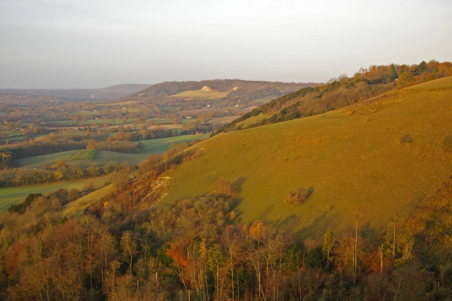
English: Sunrise on The Saddle Knob, Colley Hill This picture along the North Downs scarp was taken on a November morning, just after sunrise. The Saddle Knob is the grassy slope, with an old quarry at its foot. In the background is the much bigger Betchworth Quarry - until a few years ago its white cliff was a landmark for miles around. Now only the top shows, the rest having been used as a large landfill, now landscaped and being managed to make new downland. In the very far distance is White Downs. Box Hill, perhaps the most famous part of this stretch of the North Downs, is not visible, lying around the corner beyond Betchworth Quarry. |
| Date | |
| Source | From geograph.org.uk |
| Author | Ian Capper |
| Attribution (required by the license) | Ian Capper / Sunrise on The Saddle Knob, Colley Hill / |
| Camera location | | View this and other nearby images on: OpenStreetMap |
|---|
_heading:270.00&language=en)
| Object location | | View this and other nearby images on: OpenStreetMap |
|---|
_heading:270.00&language=en)
Licensing edit

|
This image was taken from the Geograph project collection. See this photograph's page on the Geograph website for the photographer's contact details. The copyright on this image is owned by Ian Capper and is licensed for reuse under the Creative Commons Attribution-ShareAlike 2.0 license.
|
This file is licensed under the Creative Commons Attribution-Share Alike 2.0 Generic license.
Attribution: Ian Capper
- You are free:
- to share – to copy, distribute and transmit the work
- to remix – to adapt the work
- Under the following conditions:
- attribution – You must give appropriate credit, provide a link to the license, and indicate if changes were made. You may do so in any reasonable manner, but not in any way that suggests the licensor endorses you or your use.
- share alike – If you remix, transform, or build upon the material, you must distribute your contributions under the same or compatible license as the original.
- Remove redundant categories and try to put this image in the most specific category/categories
- Remove this template
- The location categories are based on information from this geonames tool and this OpenStreetMap tool combined with a database. You can also have a look at this tool from mysociety.
- The topic category from Geograph was Downland (find similar images at Geograph)
File history
Click on a date/time to view the file as it appeared at that time.
| Date/Time | Thumbnail | Dimensions | User | Comment | |
|---|---|---|---|---|---|
| current | 07:06, 7 February 2011 | | 640 × 426 (76 KB) | GeographBot (talk | contribs) | == {{int:filedesc}} == {{Information |description={{en|1=Sunrise on The Saddle Knob, Colley Hill This picture along the North Downs scarp was taken on a November morning, just after sunrise. The Saddle Knob is the grassy slope, with an old quarry at its |
You cannot overwrite this file.
File usage on Commons
There are no pages that use this file.